Table of Contents
- Rideau River Shoreline Classification Methods. Poster presentation at Coastal Zone Canada 2004 Conference, Saint John's NewFoundland June 27-30 2004.
- Using Remote Sensing Data to Detect Sea Level Change. Poster presentation and paper for the ISPRS/ASPRS conference in Denver, Colorado. November 2002.
- GIS for Coastal Zone Management. This is a paper that I wrote for the Coastal Zone Canada 2000 conference in September, 2000 in St. John, New Brunswick, Canada.
- Transporation Geography Page. This site contains a series of maps, images, videos, and opinion about Transportation in Canada and around the world. The videos are "very" informative!
- Public Transit Information. . Information on public transit both past and present.
- Geographic Organizations.
- GIS Information.
- GIS use in Health and Medicine.
- Geographic Magazines On-Line.
- GEOGRAPHICAL NAMES.
- GOVERNMENT INFORMATION (CANADA.
- GOVERNMENT INFORMATION (U.S.)
- INTERNET Resource Guides.
- MAP LIBRARIES AND ASSOCIATIONS.
- MAPS (ON_LINE SOURCES)
- GIS Data.
- REMOTE SENSING Images and DATA.
- Weather Sites.
- Tourist/Travel Information.
- Global Positioning Systems(GPS).
- Utilities.
- Employment in GIS.
Geographic Organizations:
- The Canadian Association of Geographers (CAG) is the national organization representing practising geographers from public and private sectors and from universities. The CAG is active on many fronts: from the dissemination of geographic research to the promotion of geographic education and cooperation with international organizations.
Go back to the top of the page.
Rideau River Shoreline Classification Methods.
Abstract:
Management of the shoreline requires up-to-date knowledge of features that comprise the shoreline as well as the riparian and littoral zones. These features should be mapped and stored in a GIS (geographic information system) for mapping and analysis purposes. By applying a systematic analysis of various shoreline, riparian and littoral features the health and effectiveness of the shoreline can be determined. As well, if the shoreline areas are mapped in the future using the same criteria, then change detection procedures can be employed to measure if the health of the shoreline has improved, degraded or has remained in a contact state.
Three organizations (CSW, RVCA and Parks Canada) have cooperated to do such an analysis of a section of the Rideau River between Smiths Falls and Ottawa in Ontario, Canada. A version of M.A.P.L.E. (Mutual Association for the Protection of Lake Environment) was modified and expanded to map the shoreline features of all properties along the Rideau River in 2002 and 2003. Most of the fieldwork was done via small powerboats, which allowed access to relatively shallow inshore areas. Large-scale flood plan maps were used as base maps and various shoreline features (such as lot boundaries) were recorded with GPS. Digital photos were also taken of each property and then catalogued onto CDs. The results of the shoreline mapping were stored in a GIS and hardcopy maps were produced showing the various shoreline features including type of shoreline (natural, regenerative, ornamental, degraded), land vegetation cover, aquatic vegetation, erosion and land use. This paper examines the effectiveness of this shoreline classification procedure for the Rideau River and its potential use for other shoreline areas.
Key words: ArcView, Shoreline, Classification, M.A.P.L.E., Property Description Form, Offshore Floating Objects, GPS, GIS, Change Detection, Base Maps, Land Use, Rideau River, Rideau Valley Conservation Authority, Centre for Sustainable Watersheds.
The original WORD files that were used for that presentation are available here:
Go back to the top of the page.
Using Remote Sensing Data to Detect Sea Level Change.
On November 13, 2002 I made a poster presentation on the above topic at the ISPRS/ASPRS conference in Denver, Colorado.
The original WORD files that were used for that presentation are available here:
Paper on Using Remote Sensing Data to Detect Sea Level Change
ABSTRACT
Remote sensing data and Geographic information systems (GIS) are relatively new and potentially valuable tools for coastal zone management. This paper examines the effectiveness of using remote sensing data to detect sea level change. Since resolution is such an important and vital element of spatial digital data for use in geographic information systems, it is important to know how to assess its quality, accuracy and level of precision. Using remote sensing data to detect sea level change also requires accurate historical baseline spatial data and knowledge of how the coastline is defined and mapped. Map datum refers to the various locations to which geographic measurements are referenced. This referencing system is an important item on the list of cartographic components that help to identify and categorize individual maps. For example, many North American maps have been, or will soon be, converted to a horizontal map datum known as NAD83. Along with horizontal datum, maps are also referenced to vertical datum. The choice of vertical and horizontal map datum along with other cartographic elements such as map projection, scale and meta data will determine to what level of precision coastal change can be accurately measured. This paper will explain how to select the most appropriate baseline spatial data as well as the type of the remote sensing data that will provide the most reliable results for the detection of seal level change. Cobscook Bay, Maine was used for two case studies to demonstrate some of these coastal mapping parameters.
A Draft copy (WORD format) of a paper on the same topic is available here:
Kostiuk, M. (2002). ISPRS Paper: Using Remote Sensing Data to Detect Sea Level Change.
Go back to the top of the page.
The Use of Geographic Information Systems for Coastal Zone Management.
Cobscook Bay, Maine. A Case Study.
Michael Kostiuk
ABSTRACT
Determining the accurate length of the coastline is important for such coastal zone management applications as shoreline classification, erosion, biological resources, habitat assessment, and for the planning and response to natural(e.g. storm surges) and manmade disasters(e.g. oil spills).
The increasing use of spatial data and GIS (geographic information systems) by organisations and researchers is a valuable tool for coastal zone management. The effectiveness of the results obtained by using a GIS is dependent upon the quality of the data that goes into these systems. This data is known as spatial data, since each geographic feature in the database has its own geographic coordinates such as longitude and latitude. Another important aspect of spatial data is that of scale. As with a map, spatial data contains geographic information that is limited to the scale of the database. For example, a 1:100,000 scale map does not show as much detail as a 1:50,000 scale map because it displays an area that is four times smaller. The reduction of detail on maps is known as map generalisation. Map generalisation not only limits the amount of information that can be shown on a map, but it can also limit the accuracy of a map. The same is true of spatial data. Spatial data is simply map data in a digital format.
This paper will demonstrate how five different types of spatial data produce different results for shoreline length, high water area, and the number of islands in Cobscook Bay, Maine.
To see the the entire paper, follow this link: GIS For Coastal Zone Management
Go back to the top of the page.
Upcoming Coastal GIS Conference:
Ottawa Streetcar 696 Restoration Group
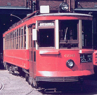
This section describes the restoration of Ottawa streetcar 696.
This area contains information about the projects as well as a brief history of Ottawa streetcars with pictures.
Enter Here: to go to Streetcar 696.
Go back to the top of the page.
How Ottawa can Save 75 Million!
Convert the South-East Transitway to Light Rail First:
Follow this link to learn how the City of Ottawa can save $75 Million dollars by converting the South-East Transitway to Light Rail instead of Double Tracking the North-South O-Train line.
Click here: Save $75 Million.
Go back to the top of the page.
Denver LRT, a Model for Ottawa's Proposed Light Rail System
Read about the successful Denver, Colorado Light Rail system and how the same methods and technology can be applied for the proposed Light Rail System for Ottawa. To read more, go to this link: Denver LRT: A model for Ottawa.
Sites relating to Public Transportation:
- Transporation Geography Page. This site contains a series of maps, images, videos, and opinion about Transportation in Canada and around the world. The videos are "very" informative!
- Transport Action. Transport Action (formely Transport 2000) believes that transportation is more than just a means of moving goods and people, measured only by profits or political benefits. Transport 2000 believes that public transportation impacts on land use, economic development and the quality of life. Transportation is a tool to protect the environment, conserve energy, diminish land pressures, curtail the growth of road and highway spending and promote economic growth.
Go back to the top of the page.
GIS INFORMATION
The following links are a small sample of GIS and Geography related information that can be found on the Internet.
- Spatial Manager. GIS Apllications for for Desktop and AutoCad
- Idrisi Project Home Page The Clark Labs is a non-profit research organization within the Graduate School of Geography at Clark University. Activities undertaken by the Labs include: the development, distribution and support of the raster Geographic Information System and Image Processing software IDRISI and the vector digitizing and editing software CartaLinx.
- ESRI, Home of The GIS People. ESRI is the world's leading provider of GIS software, according to computer industry analysts.
- ESRI Canada. A Leader in GIS software such as ArcInfo, ArcView, pcTIN and ArcForest.
- PCI Home Page Product Overview: Remote Sensing, Digital Photogrammetry, Image Interpretation, Image Visualization, Digital Cartography, and Spatial Analysis.
- MapInfo Home Page GIS,mapping and demographic analysis solutions.
- GeoPlace.ComThe world's leading provider of geospatial information.
- GIS Dictionary (U. of Edinburg & Association for Geographic Information This is the original edition of the dictionary of GIS terms, brought to you by the University Of Edinburgh Department of Geography and the Association for Geographic Information.
- Geographical Information Systems (GIS) WWW Resource List This is one of the best sites for GIS information and it is big!.
- Intergraph Mapping/GIS Makers of the following GIS/Mapping products and solutions: MGE, GeoMedia Pro, GeoMedia, GeoMedia Network, GeoMedia Web Map, GeoMedia Viewer, GIS Office, and GEOVEC Office.
- Manifold GIS. Manifold is a new type of software to display and manipulate data. It is often used for Geographic Information Systems (GIS), that is, map drawing and analysis, but it can be used to visualize and manipulate just about any kind of data. From the Home page of Manifold.net
- The Geography Home Page This site has weekly articles about geography, annotated links to hundreds of the best sites for maps and geographical information, a glossary, weekly quizzes, a bulletin board and chat room for those interested in geography and much more.
- Sagres Editora's GIS home page from Brazil. In Portuguese. He is planning to translate it to Engish soon.
- Safe Software Inc offers a GIS utility that translates/converts data between many GIS and CAD formats.
- SOFTREE Map drawing software for the natural resource industries.
- CARIS _ Universal Systems Ltd, Developers of CARIS Marine Information Systems, CARIS GIS, CARIS Internet Server, GIS in Geology and CARIS++ Spatial Framework.
- The GeoCommunity Web site is a resource for GIS/CAD professionals. Visit this site for FREE downloads from over a terabyte of geospatial datasets, a high_powered, industry_specific search engine, GIS industry news, discussion forums, classifieds, and software utilities.
- Pinebush Technologies, Inc., Located in Albany, N.Y., is a worldwide leading developer and supplier of high performance visualization printing and plotting software for EDA, Semiconductor, CAD, GIS, mapping, engineering and other technology applications.
- GISMalaysia.com GIS in Malaysia.
- MyGIS.com.my MyGIS - Malaysia Geographic Information System. MyGIS - Malaysia Geographic Information System, with free GIS email, ArcView-L SUM archived by topic, free scripts and much more to come ...
- GISdevelopment.net which is into the exclusive promotion and awareness of GIS throughout Asia.
- Centre for Spatial Database Management & Solutions. As the leading regional center committed to the promotion of GIS and its usage in various development activities, CSDMS assists South Asian community in developing their capabilities and policies to maximize the benefits of GIS through advocacy, training, information and the provision of expert advice and assistance.
- Caliper Corporation. Makers of Maptitude and TransCAD. Maptitude is a professional mapping software for Windows with an extensive set of features and data. Reasonably priced, Maptitude contains all of the functions found in more expensive GIS products, and ships with a lot of geographic data. TransCAD is a GIS software package that contains extensive geo-statistical functions including spatial correlations,model estimation, and model evaluation. In addition, TransCAD has also functions for estimation of statistical models used in transportation planning, such as estimates of home-to-work travel demand.
Go back to the top of the page.
GIS use in Health and Medicine
Go back to the top of the page.
Geographic Magazines On-Line.
- Canadian Geographic.
- National Geographic.
- Mercator�s World: The Magazine of Maps, Exploration, and Discovery.
Go back to the top of the page.
GEOGRAPHICAL NAMES
- U.S. Defense Mapping Geographic Names Database Use guest as user name and password
- TIGER Mapping Service. The "Coast to Coast" Digital Map Database. A project sponsored by the U.S. Bureau of the Census. The goal of this service is to provide a public resource for generating high-quality, detailed maps of anywhere in the United States, using public geographic data.
Go back to the top of the page.
GOVERNMENT INFORMATION (CANADA)
- Government of Canada Home Page. Government of Canada Primary Internet Site (Canada Site) is the Internet electronic access point through which Internet users around the world can obtain information about Canada, its government and its services.
- Canada Centre for Remote Sensing The Canada Centre for Remote Sensing (CCRS) is internationally recognized as a leading centre of excellence in the use of earth_observation data, and supports an expanding industry sector including the world leaders in global ground station, image analysis and radar mapping markets. CCRS is responsible for the reception, processing, archiving and dissemination of remotely sensed data for Canada.
- GeoConnections supports projects that enable decision-makers to use location-based information to benefit public health, safety and security, the environment, and Aboriginal communities.
- National Atlas Information Service The National Atlas of Canada is responsible for the development and maintenance of an authoritative synthesis of the geography of Canada. Products, in both digital and conventional form, include base maps, and thematic maps that reflect the social, economic, environmental and cultural fabric of Canada. Customized On-line map services are also provided.
- Natural Resources Canada. Natural Resources Canada (NRCan) is a federal government department specializing in energy, minerals and metals, forests and earth sciences.
- Statistics Canada This site has statistical information profiling Canada's business, economy and society.
Go back to the top of the page.
GOVERNMENT INFORMATION (U.S.)
- United States Geological Survey The U.S. Geological Survey provides the Nation with reliable, impartial information to describe and understand the Earth.
- Census Bureau Home Page Census Bureau Mission: To be the preeminent collector and provider of timely, relevant, and quality data about the people and economy of the United States.
- Earthquake Info from the U.S.G.S. Earthquake Information.
- NASA Jet Propulsion Laboratory Managed for NASA by the California Institute of Technology, the Jet Propulsion Laboratory is the lead U.S. center for robotic exploration of the solar system.
- NASA Solar Data Analysis Center The Solar Data Analysis Center at NASA Goddard Space Flight Center in Greenbelt, Maryland USA.
- NOAA National Oceanographic Data Center (NODC) Home Page The U.S. National Oceanographic Data Center (NODC) holds the world's largest collection of publicly available oceanographic data.
- C.I.A. The home page for the Central Intelligence Agency. A large amount of information is available about the world. Check out the section on the CIA factbook about countries around the world. There is also an extensive section on country maps.
- C.I.A. Maps. C.I.A. Maps & Publications.
Go back to the top of the page.
INTERNET Resource Guides
- CEONET has an extensive search and catalogue of geomatics products and services.
- CIESIN Consortium for International Earth Science Information Network CIESIN specializes in global and regional network development, science data management, decision support, and training, education and technical consultation services. CIESIN is the World Data Center A (WDC_A) for Human Interactions in the Environment.
Go back to the top of the page.
MAP LIBRARIES AND ASSOCIATIONS
- Alexandria Digital Library The Alexandria Project. It is run by are a consortium of researchers, developers, and educators, spanning the academic, public, and private sectors, exploring a variety of problems related to a distributed digital library for geographically_referenced information.
- Earth Sciences & Map Library Home Page UC Berkeley Earth Sciences and Map Library.
- Carleton University Map Library Home Page Carleton University Map Library was founded in the mid 1960s by the Department of Geography. By 1970 the collection comprised some 60,000 map sheets and several hundred atlases and reference works _ a core collection of Canadian materials and the nucleus of a foreign collection, mainly centred on Western Europe and the Soviet Union. The Map Library was absorbed administratively by the University Library in 1975, when it became a department of the Library's Information Services Division. The Map Library now holds the Library's entire collection of cartographic materials (in a variety of formats: atlases, sheet maps, microforms, digital maps) and cartographic reference works. The collection comprises some 150,000 sheet maps, 2,500 atlases, approximately 3,500 cartographic reference works, and 25,000 items in other formats.
- California Geographical Survey (California State University) The Internet Library of the Department of Geography at California State University Northridge. This facility is operated by the Department of Geography and the Center for Geographic Research for the benefit of the people of the State of California and the students and faculty of the California State University System. It is the California Geographical Survey's intention to provide a variety of important geographic resources to the entire Internet community.
Go back to the top of the page.
MAPS (ON_LINE SOURCES)
- DEMIS World Map Server. This Map Server demo started as a small research project to connect our Map Engine
- CIA maps and other (U. of Texas at Austin) On_line Maps of Special Interest from the University of Texas at Austin.
- Color Landform Atlas of the United States This is version 2 of the Color Landform Atlas of the United States. It has less glitz ( see one of the old state pages) but more content. Each state link brings up a menu of links to maps and other online information about the state. Also includes links to other sources of state related information (Yahoo, City_Net, etc.)
- Paris Maps Paris Maps _ Slide List Prof. Barry Bergdoll, Art History: University of Columbia.
- The Electronic Map Library (Dept. of Geography, California State U.) The Electronic Map Library includes a series of atlases currently being produced by individual authors or project groups. The majority of these volumes are being frequently enlarged and modified in response to the changing instructional needs of the Department of Geography atCalifornia State University Northridge.
- Historical Maps of New World and U.S.A. The Hargrett Rare Books and Manuscripts Library at the University of Georgia maintains a collection of about 800 historical maps spanning nearly 500 years, from the sixteenth century through the early twentieth century.
- New York Map Portfolio New York State Historical Maps by David Yehling Allen. Most of the maps at this site derive from a Kodak Photo CD portfolio of early maps covering all or part of New York State. The images are medium resolution photos in compressed JPEG format.
Go back to the top of the page.
GIS Data
- GIS Data Depot. The purpose of the GIS Data Depot is to promote the open exchange and free transfer of geospatial
data over the Internet. The GIS Data Depot currently has over 50,000 unique web pages containing
free geographic data for 250 countries. This is a commercial site that also provides free access to spatial data.
- Geogratis distributes geospatial data of
Canada. Data is available for download, without charge!
- The GeoCommunity Web site is a resource for GIS/CAD professionals. Visit this site for FREE downloads from over a terabyte of geospatial datasets.
Go back to the top of the page.
REMOTE SENSING Images and DATA
- RADARSAT International High resolution images from Radarsat.
- The Earth Resources Observation Systems (EROS) Data Center (EDC) The EDC's mission has changed and grown over the years. Its original mission was to receive, process, and distribute data collected and transmitted to the EDC by National Aeronautics and Space Administration (NASA) Landsat satellites.
- R&D center ScanEx. Research & Development Center ScanEx is a Russian private company providing full integrated solutions for satellite remote sensing applications. They can offer cost-effective innovative technologies for Earth imagery collection, dissemination and problem-solving use.
- Earth Picture List Many different types of earth images.
Go back to the top of the page.
Weather Sites
- The Weather Office Environment Canada's weather site. Local, regional, national and international weather forecasts. Access to satellite images, radar, aviation data and current lighting activity in Canada and the northern United States.
- Unisys Weather ProcessorThis site has various types of satellite and radar images which can be viewed as single pictures or as a movie.
- National Climate Data Centre. NCDC is the world's largest active archive of weather data. NCDC produces numerous climate publications and responds to data requests from all over the world.
- Weatherundergrund.com What you need, when you need it. Extensive weather related prducts and services.
Go back to the top of the page.
TOURIST/TRAVEL INFORMATION
- Google Maps. Maps and high resolution satellite Imagery. Map viewers, Trip planners and more.
- Yahoo! Maps This sites produces a map(s) of
locations in the United States of America and Canada as well as producing maps for driving directions
combined with a text explanation of the route between chosen locations.
- Excite Travel Travel maps, travel news, discount fares and other types of useful information for the traveller.
Go back to the top of the page.
Global Positioning Systems(GPS)
Note: SA has been turned as of May 1, 2000!
- Trimble _ All About GPS A superb on_line tutorial on how GPS works. From the Trimble home page.
Go back to the top of the page.
UTILITIES
- AnGIS Software Incorporated authors the DataMorpher GIS utility that builds projects, transforms data between many GIS and database formats, and operates in interactive and unattended modes.
- Safe Software Inc. offers a GIS utility that translates/converts data between many GIS and CAD formats.
Go back to the top of the page.
Employment in GIS
- GIS Jobs Clearinghouse the new GIS Jobs Clearinghouse. Started in 1992,
the GJC has helped thousands of GIS/RS professionals find
positions. With hundreds of positions and resumes in our databases,
the GJC has resources for both employers and those seeking jobs.
- GISLinx. Internet Resource Guides. Employment in GIS.
- GEO Job Source . This site features GIS and GIS_related job opportunities.
- GIScareers.com is devoted to GIS Job and Resume posting.
- GISjobs International GISjobs International - Recruitment and Information Services Totally Dedicated to the GIS Professional.
Go back to the top of the page.