Legend
News!

This page has been selected as one of the TOP TEN Transportation Geography Sites to be cited for Geography Awareness week for 2009. A complete list of the ten sites can be found Here: Transportation Day 2009.

More Information about this recognition is available at the bottom of this page: Transportation Day Recognition.
Note: A list of all Videos is located at the Bottom of this page.
Save 75 Million!
Convert the South-East Transitway to Light Rail First:
Describing the $75 Million cost saving of converting the South-East Transitway
to Light Rail as opposed to converting the North-South O-Train line to double track Light Rail.
Attention: If you cannot connect to YouTube the video can also be downloaded on this site here:
Convert S.E. Transitway
I am geographer and a teacher, but I also have been a student of local planning in Ottawa since the mid 1970s. I recall that when the Bus-based Transitway was first proposed in the 1970s that it was designed and built so that it could be converted to rail-based transit service when the density of bus use reached a certain threshold. Stations, grade separation and roadways were designed so that Light Rail could be quickly and economically built and operated on the Transitway when it was time to convert the system to light Rail.
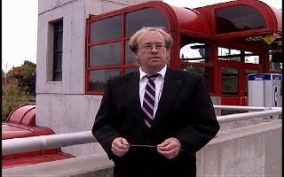
Michael Kostiuk
In comparison, the pilot project that was done on the railway line now occupied by the Ottawa O-Train was done to show how existing railway lines could be modified for commuter rail, as well as providing an auxiliary service to fill a transit need that was not being addressed by either buses or a future light rail system. It was not intended to replace the South-East Transitway as a light rail route to downtown since the cost of converting it to double track with grade separation would be very expensive. Conversely, the South-East Transitway is ready for conversion to Light Rail use since it is grade separated and it also connects commuters to downtown and the east end of the city via the Hurdman station.
Unfortunately, these long terms plans from the 1970s have become confused and crisscrossed over the decades and we have a bus-based Transitway that is only being partially planned for conversion to light rail. The South-East Transitway is to remain for use by bus transit only. Meanwhile, the North-South O-Train line that was to serve as a pilot project for commuter rail will be converted to double track light rail at a VERY high cost. We also have a downtown tunnel that is to be the main spine for an east-west light rail service and until it is built and operational, a functional light rail system cannot be built and put into operation for Ottawa.
Based on what I have learned over the past 30 years about commuter rail (and building on the knowledge of many other people such as, but not limited to: Wellar, Doucet, Renfrew, Gow, Lane and Jeanes) it seems that if we were to go back to the original plan set out in the 1970s we could start building and operating a light rail system sooner and cheaper than is being proposed by the City of Ottawa.
I suggest that it could be done in the following manner:
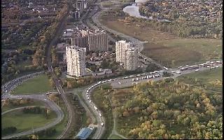
Step one: Convert the South-East Transitway from Greenboro to Hurdman instead of double tracking the current O-Train from Greenboro to Bayview. We should convert the South-East Transit way to light rail now based on the premise that it was designed to be converted to light rail service when the density of bus use reached a necessary threshold. Experts in public transit have stated that corridors that are used for public transit are suitable for buses if the passenger capacity is less than 2000 users per direction per hour. When the capacity reaches 2000 users per direction /hour then the system would be better served if it were converted to light rail. Currently the capacity on the South-East Transitway is approximately 3500 users per direction /hour and therefore, it has already surpassed the threshold for conversion to light rail.
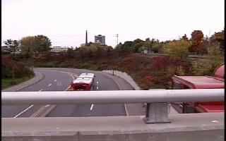
South-East Transitway at Pleasant Park Station
As well, the South-East Transitway is grade separated, the stations are built to light rail standards and of course, it serves several important stops such as South Keys, the government employment Centre of Confederation Heights, Billings Bridge Plaza and the Riverside Hospital.
According to details provided by a recent graduate of a Masters in Planning program (David P James) in Calgary the cost of double tracking the North–South corridor that is occupied by the current O-Train is $75 million dollars more expensive that converting the South-East Transitway to light rail.
And, according to the April 2008 City of Ottawa Transit Report the North-South Light Rail cost in the Bayview-Greenboro corridor is $227 Million. If the same conversion costing methodology used on the East Transitway is applied to the South-East Transitway, the result is a cost of $152 Million, or a difference of $75 Million.
However, this information should hardly be surprising since such a project as the North-South Line requires widening the trench, moving the rail lines, building a parallel tunnel under Dow’s Lake, building a bridge over the Rideau River, widening the bridge under Heron Road, grade crossings for the Via tracks and the Walkley Yard, expanding the stations and double tracking the line. As Tim Lane pointed out:
"you can ONLY justify doing this expensive construction, if you then shift most of the people using buses on
the South-East Transitway to get from the south end to downtown, onto the ELRT trains that would now be running on the
O-Train line.
If you DON'T do this shift, and continue running large numbers of buses on the South-East Transitway,
then you will have done NOTHING to reduce bus operating costs, and you will also be THROWING AWAY the huge investment
you will just have made, in beefing up the O-Train line.to double track ELRT."
Converting the South-East Transitway to Light Rail would also solve the load imbalance identified by Mr.Klaus Beltzner, where he pointed out that when you
consider the vast numbers of STO riders coming into downtown Ottawa, there are already too many people entering
Ottawa's downtown from the west, compared to the east.
Conversely, feeding all of the flows from the south, along an upgraded Double-Track the O-Train
line, and into downtown from the west, would exacerbate this
imbalance.
Step two: Convert the Transitway from Hurdman to Blair (or farther east). Construction of the Light Rail Tracks can be done at night, on weekends and during the summer vacation period to lesson impact on existing service. Buses can also temporarily use alternate routes on nearby roads ways such as the Queensway for the Hurdman to Blair section and roads such as Riverside Drive and the Airport Parkway for the South-East Transitway
Step three: Place the Light Rail garage/maintenance facility in the east or south end of the city.
The Light Rail yard can be built in one of three locations that has been discussed over the years:
- Walkley yard where the current O Train is stored
- Belfast Road Location
- Bowesville location that was chosen in the cancelled North- South Project.
All three locations would be suitable for supporting light rail in the east and southeast Transitway corridors.
This route would NOT require the Light Rail Train to go through downtown Ottawa and it could be set up before the tunnel is completed and is ready for use.
This allows for the building of a Light Rail storage and maintenance facility, the purchase and delivery of Light Rail Vehicles and the training of staff. This is vital since there must be a facility for light rail storage and training BEFORE the light rail system is made operational.
Step four: operate the Light Rail from Greenboro to Hurdman and from Hurdman to Blair (or farther east).
Light Rail Transit users that are going downtown will get off at Hurdman and be transported downtown via bus and vice versa. Those transit riders that are going East or South will continue their journey on the Light Rail Train or transfer to a light Rail vehicle that is heading in that direction.
Hurdman Station.
Intersection of East and South-East Transitways
Step 5: Operate the Light Rail Line from Hurdman through downtown Ottawa west to Tunney’s Pasture/Lincoln Fields Station when the tunnel is completed and operational. Connections can also be made to the North-South Line and the Carling Avenue Line when it is built.
Note: The savings in $75 million dollars that is gained from converting the South-East Transitway for light rail can be applied to the building of the tunnel under downtown Ottawa or it could be applied to expanding the conversion of light rail on the west section of the Transitway.
The future South-East Light Rail system can be built cheaper and sooner than converting the North-South O-Train line. I must emphasis both CHEAPER and SOONER since it is easier, quicker and cheaper to lay rail than to build the massive infrastructure that is required for the North-South Line (BEFORE rail can be put in place).
The current North-South O-Train system could also be expanded north across the Ottawa River and south as well if it is deemed necessary. This would allow rail-based service into Gatineau possibly up to the Casino de Lac Leamy. Such a service would help to reduce the number of buses and cars crossing the Ottawa River on a daily basis.
By following the transit plans that the City of Ottawa established in the 1970s we can have a Light Rail-based Rapid Transit Service sooner and cheaper than is currently being proposed. In these current times of global economic uncertainty isn't’t saving $75 million worth it?
Michael Kostiuk MA Geography, B. Ed. OCT, CCEP.
Additional support material is available here:
-
A pdf format map showing the location of the South-East and East Transitways as well as the locations of the three potential Light Rail Maintenance/Storage Yards.
-
Copies (pdf format) of the relevant sections of the April Transit report that details the costs of converting the North-South East Transitways to Light Rail. Report 1. Report 4.
-
Video of Michael Kostiuk on YouTube describing the $75 Million cost saving of converting the South-East Transitway to Light Rail as opposed to converting the North-South O-Train line to double track Light Rail.
More Videos Here:
The following Videos and files on similar topics are available here:
Note: If you have a video viewing program such as Real Player (Available here: Real Player) you can also download the following videos to your computer
As an aid to using these videos I have also created a site with maps of many of these sites. You can view these maps by going to: Transportation Geography.
-
Highway 7 Overpass at Ashton Station. Coming very soon. This is a video that is currently in production to investigate and ask questions about the inadequate size of the new overpass that is being built at this location. This is a former Canadian Pacific rail road corridor that was purchased by the former Regional Municipality of Ottawa-Carleton (New City of Ottawa) for long term use as Transportation and utility corridor. However, the new overpass is too small for future rail use! Watch and be amazed and angered when you see what is happening to our valuable rail/transportation resources at this location in Eastern Ontario.
-
Highway 7 Overpass. Map of the former CPR Right of Way between Carleton Place and Bells Corners. Why is that corridor not being used for rail-based transportation? Why is the new Highway 7 overpass that is being built over this right of way, not large enough for future rail use? Why has planning and building for Sustainable Development gone so wrong in this part of eastern Ontario?
-
Air and Sound (Noise) Pollution created by traffic congestion in downtown Ottawa. Too many trucks and buses are going through the centre of the city. Meanwhile, the nearby Prince of Wales Railway Bridge sits idle.
-
A Simple Plan is a collection of short videos explaining a number of Transport 2000 ideas on how to get Ottawa's Light Rail system working sooner, more effectively and for less money. Source: Dunrobin Castle
-
Ottawa Light Rail Driver Interview Opinions on how to build and run Light Rail on existing Railway Tracks from a former O-Train Driver (retired).
-
Use The Inter-City "P.O.W." Rail Bridge This video explains why we should be using the "UNUSED" Prince of Wales Railway Bridge that connects downtown Ottawa to downtown Gatineau (Hull). Source: Dunrobin Castle. www.dunrobincastle.com
-
Map of the area around the Prince of Wales Railway Bridge. This is a major railway bridge that crosses the Ottawa River between downtown Ottawa and downtown Gatineau (Hull). However, this bridge sits unused while thousands of cars, trucks and buses clog the downtown streets on both side of the Ottawa River. Why is there no rail-based transit using the Prince of Wales Bridge? The O-Train stops at the nearby Bayview station, but it could very easily be extended across the Prince of Wales Bridge to Gatineau.
-
James Allen Ottawa Central Railway on Using Existing Rail Dick Howey Interviews James Allen of the Ottawa Central Railway about the ease of establishing Light Rail service on existing railway tracks in the Ottawa area.
-
High Cost - How to Save Money. Klaus Beltzner details how the cost of implementing Rapid Transit can be >>>greatly<<< reduced. i.e. we are talking Millions of Dollars of savings!
-
Dow's Lake Tunnel Issue. Tim Lane explains why we should not build a second tunnel and double track the O-Train line under Dow's Lake at the Arboretum. Source: Dunrobin Castle. www.dunrobincastle.com
-
Prince of Wales Railway Bridge High Rail Inspection 'North-Bound' Ride. This video shows the North Bound view of the Prince of Wales Railway via a high rail inspection truck. The voices of Perry Huneault, Canadian Pacific Railway maintenance of way foreman, driving the truck, can be heard along with comments from Chris Holloway, the
official Transport 2000 staff photographer for this trip.
-
Prince of Wales Bridge High Rail Inspection 'South-Bound' Ride This video shows the South Bound view of the Prince of Wales Railway via a high rail inspection truck. The video camera work and some of the narration is by Tim Lane.
-
Ottawa Light Rail Show. Many of the videos indicated above are also located at the Dunrobincastle site. This is a useful link if your organization does not allow access to YouTube videos.
-
Saar Light Rail Part 1: Regional Electric Light Rail Train. Operating as a Commuter Train on Regional Rail Lines between Germany and France.
-
Saar Light Rail Part 2: In this video the Light Rail Train changes from "Regional/Commuter" Service to Tram or Street mode. The operating voltage also goes through a transition from 15,000 Volt AC inter-city service to 750 Volt DC Tram Service.
-
Saar Light Rail Part 3: Same Saar Light Rail Train operating as a Tram on City streets.
-
Arrival of the O Train. This video shows the delivery of the Bombardier "Talent" O Trains to Ottawa on 2001.
-
O Train Funding announcement. Video of the 2004 Funding Announcement for the North-South Light Rail Project. Federal, Provincial and city of Ottawa officials gathered at the Fallowfield VIA Station in Barrhaven to announce Three Level government funding for the project. Note: The O Train sits idle on the east-west VIA line during this ceremony.
-
O Train after the strike. This video shows the O Train back in operation after the 52 day Transit strike in Ottawa. The strike lasted from November 2008 to February 2009. The O Train was the first part of the Ottawa Transit system to go back into service. Despite the lack of connecting buses, the O Train carried about 5000 riders per day. This video shows that the O Train generates a substantial amount of its own ridership and does not necessarily rely on people transferring to or from it, via buses.
-
O Train shares its tracks with freight trains. Despite what most people are aware of, the O Train shares a portion of its track with Freight Trains. This occurs in the south section of its track between the Walkley Yard and the Greenboro station. Also available here: Shared Tracks.
-
Modifying the Carleton U Platform. Tim Lane and David Jeanes shows how to improve the pedestrian usage of the O Train Platform at Carleton University through a few simple alternations. Also available here: Carleton Platform.
-
How to run Light Rail on surface streets in downtown Ottawa. Part One: Slater Street. These series of videos explain how it is both feasible and cost effective to build and operate a Rapid Transit Light Rail system on surface streets through downtown Ottawa. David Jeanes (P. Eng), President of Transport 2000 demonstrates (via maps of downtown Ottawa and scale model cut-outs of 4-car Light Rail vehicles) how stations can be placed on many sections of Slater Street. There are three videos in this series. Made by Friends of the O Train. April 2009. Ottawa, Canada.
-
How to run Light Rail on surface streets in downtown Ottawa. Part Two: Albert Street. David Jeanes (P. Eng), President of Transport 2000 demonstrates how stations can be placed on many sections of Albert Streets as well as on the McKenzie King Bridge. There are three videos in this series. Made by Friends of the O Train. April 2009. Ottawa, Canada.
-
How to run Light Rail on surface streets in downtown Ottawa. Part Three: MacKenzie King Bridge Stations. David Jeanes (P. Eng), President of Transport 2000 demonstrates how stations can be placed on many sections of the McKenzie King Bridge through to the University of Ottawa. Includes a summary of the three videos on how "surface" Light Rail can improve both the environment and commercial vitality of downtown streets. Also includes a summary by Michael Kostiuk (MA Geography) about the superiority of "street-level" Mass Transit as opposed to "Tunnel-based" Mass Transit. There are three videos in this series. Made by Friends of the O Train. April 2009. Ottawa, Canada.
-
Light Rail on Surface Streets. Examples of different types of light rail systems that are used on city streets around the world. Coming soon!
-
The end of Ottawa's Streetcars in 1959. A commemorative video on the streetcars that were "thrown away" by the City of Ottawa on May 4, 1959.
This is a special commemorative video of the 50th anniversary of the end of the streetcar system in Ottawa Canada.
Source and permission to use the video is from Raymond Langlois. It also has scenes of the 1000 series streetcars in Ottawa, rare because only 4 of this type were made, and they were withdrawn from service some time before the end of the streetcar era in 1959.
Regular venue Streetcar service in Ottawa came to on April 30, 1959.
-
Dnipropetrovsk Trams Part 1. Trams and Light Rail in and around the Ukrainian City of Dnipropetrovsk. Video starts off outside the Main "Vokshol" Railway Station with additional views of the Trams along the Pedestrian Boulevard with a brief view of Trams operating on central Boulevards out in the suburbs.
-
Dnipropetrovsk Trams Part 2.
Trams and Light Rail in and around the Ukrainian City of Dnipropetrovsk.
Views of Trams along the Main Pedestrian Boulevard as well as scenes of Trams in the City Centre.
Concludes with some night time views of Trams in the Centre of the City.
-
Ottawa Central Cab Ride. Ottawa to Pembroke. October 2003.
Video of a ride in an Ottawa Central Railway Locomotive on October 15, 2003. This video shows details of a typical day on the Ottawa to Pembroke route via Portage du Fort Quebec. Nice views of the crossing of the Ottawa River.
-
March of Time 1945 A public Domain film now available on the Intenet Archives. This film is a tour of the modern interurban trolley system of San Francisco's East Bay and over the San Francisco-Oakland Bay Bridge. Predicts the bright postwar future of streetcar transit, with visionary images of advanced-design railcars. The Key System transbay service was abandoned in 1961.
Pedestrian Related Issues
-
Carlington Pedestrian Safety. Autumn 2009. Part 1 of 4. This is part one of a series of videos that highlight many of the Walkability, Pedestrian Safety, and Cycling issues that exist in and around the Carlington Community in Ottawa, Ontario, Canada.
The time frame for these videos are the autumn of 2009. Part 1 of 4
-
Carlington Pedestrian Safety. Autumn 2009. Part 2 of 4. This is a series of videos that highlight many of the Walkability, Pedestrian Safety, and Cycling issues that exist in and around the Carlington Community in Ottawa, Ontario, Canada.
The time frame for these videos are the autumn of 2009.
Part 2 of 4
-
Carlington Pedestrian Safety. Autumn 2009. Part 3 of 4. This is a series of videos that highlight many of the Walkability, Pedestrian Safety, and Cycling issues that exist in and around the Carlington Community in Ottawa, Ontario, Canada.
The time frame for these videos are the autumn of 2009.
Part 3 of 4
-
Carlington Pedestrian Safety. Autumn 2009. Part 4 of 4. This is a series of videos that highlight many of the Walkability, Pedestrian Safety, and Cycling issues that exist in and around the Carlington Community in Ottawa, Ontario, Canada.
The time frame for these videos are the autumn of 2009.
Part 4 of 4
Links to Other Transportation Geography Related Sites
-
Friends of the O-Train. This is the Official site for the Friends of the O Train.
-
Action 2000 (A.K.A. Transport 2000.) is a non-profit organization whose primary purpose is research, public education and consumer advocacy. It promotes environmentally-sound transportation solutions and gets actively involved in a wide range of issues such as: public transportation, safety, accessibility, energy efficiency, protection of the environment, intermodal cooperation and government regulation.
-
Michael Kostiuk's Geography page. Various geography related topics such as Maps, Geographic Information Systems, Coastal Zone Management and Urban Transit are located there.
-
David James' Master's Degree Project: Ottawa's Transitway: From Busway to Light Rail. A Master's Degree Project
Submitted to the
Faculty of Environmental Design
University of Calgary, Calgary Alberta in partial fulfillment of the requirements for the Degree of
Master of Environmental Design (Planning). Ottawa's Transitway is a well-known implementation of bus rapid transit (BRT). Its main feature is the use of busways or bus-only roadways that separate buses from all other traffic, often by grade separation, to allow buses to maintain reliable rapid transit service. The busways were originally conceived of as technology-neutral transitways and were designed to allow conversion to a rail-based technology should the need arise. While convertibility to rail has been designed into Ottawa's transitways, no consideration was given to undertaking it without shutting down rapid transit service. This Master's Degree Project proposes a solution to the conversion problem by employing the use of interim single track rail infrastructure during conversion.
-
Ottawa Streetcar 696 Restoration Project. Information about the Ottawa Streetcar 696/905 Restoration Group and other Ottawa Streetcars.
-
Denver Light Rail. A Model for Ottawa's Proposed Light Rail System. Read about the successful Denver, Colorado Light Rail system and how the same methods and technology could be applied for the proposed Light Rail System for Ottawa. To read more, go to this link: Denver LRT: A model for Ottawa.
TRANSPORTATION DAY WEBSITES
Dr. Barry Wellar, Program Chair
Geography Awareness Week 2009
Canadian Association of Geographers
Your web site has been selected as one of the ten outstanding Canadian web sites to be cited
for Transportation Day, Geography Awareness Week 2009, Canadian Association
of Geographers. The description of your web site and the reasons for its selection can be
viewed at: www.cag-acg.ca/files/pdf/GAW/GAW_2009_Transportation_Day.pdf
You are welcome to announce the recognition given to your web site, and it
would be most appreciated if you added a note about Transportation Day, and a
link to the Transportation Day page, to your web site.
The introductions to Transportation Day 2007 and 2008 contain many of the basic
elements in the connection between geography and transportation, and serve as
background for 2009. As a result, the focus of commentaries for 2009 is on important,
prevailing geography-transportation processes and trends that are captured by
web sites selected for the Transportation Day component of Geography Awareness
Week 2009.
In terms of organization, the web sites which are national in scale are presented first,
followed by those which involve geography-transport topics, issues, etc., that have a
provincial, regional or local orientation. The following topics are among those that are
frequently mentioned in many and in some cases all the web sites:
- Geography and sustainable transportation
- Geography and transportation analysis
- Geography and transportation futures
- Geography and transportation infrastructure(s)
- Geography and transportation issues
- Geography and transportation networks
- Geography and transportation patterns
- Geography and transportation planning
- Geography and transportation research
- Geography and transportation strategies
- Geography and transportation systems
The web sites for Transportation Day 2009 were selected by Barry Wellar, Professor
Emeritus, University of Ottawa, Distinguished Research Fellow at Transport Canada
2000, and Principal, Wellar Consulting Inc.
Michael Kostiuk, MA Geography, B. Ed.
Last update: January 30, 2010.
Free Video!
Return to Michael Kostiuk's home page