Ottawa, Ontario, Canada: Uppertown / Parliament Hill
Evolution of an Ottawa Neighbourhood

 May 12, 2021:
Picture Source: From War to Winterlude, 150 Years on the Rideau Canal, By Mary E. Peck,
ISBN 0-660-51015-4, 1982, page 95.
Parliament Buildings Under Construction, c. 1862
Keywords: Elihu B. Spencer
May 12, 2021:
Picture Source: From War to Winterlude, 150 Years on the Rideau Canal, By Mary E. Peck,
ISBN 0-660-51015-4, 1982, page 95.
Parliament Buildings Under Construction, c. 1862
Keywords: Elihu B. Spencer

May 9, 2021:
Picture Source: From War to Winterlude, 150 Years on the Rideau Canal, By Mary E. Peck,
ISBN 0-660-51015-4, 1982, page 26.
Barrack Hill ca. 1827
Keywords: Colonel William Denny

January 5, 2020:
This is print number 31 from Selections from Picturesque Canada: An Affectionate Look Back, Pandora Publishing Company,
Victoria B.C., 1975, no ISBN.
View from the Ceremonial Battery at Major's Hill Park to Parliament Hill, c. 1880

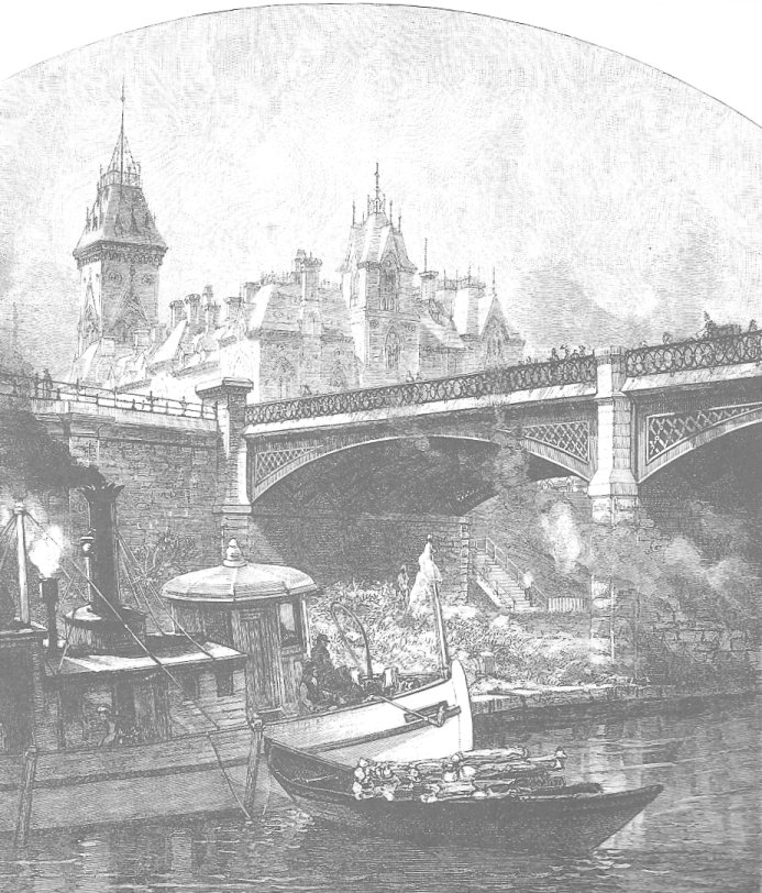
December 1, 2020:
The Dufferin Bridge under construction in 1874
This picture is from page 111 of the book Ottawa: The Capital of Canada, by Shirley E. Woods Jr.,
Doubleday, 1980, ISBN 0-385-14722-8
Keywords: Dufresne and McGarity, Wholesale Grocers

November 13, 2020:
Central Park in Ottawa, Bank Street at Patterson and Powell
This picture is from page 170 of the book Ottawa: City of the Big Ears, by Robert Haig, 1969,
Haig and Haig Publishing Company, Ottawa, no ISBN.
Keywords: Ottawa Improvement Commission, Federal District Commission, National Capital Commission, Patterson's Creek

November 13, 2020:
City Hall on Elgin Street, 1875-1931
This picture is from page 176 of the book Ottawa: City of the Big Ears, by Robert Haig, 1969,
Haig and Haig Publishing Company, Ottawa, no ISBN.
Keywords: Ottawa City Hall on Elgin Street

November 13, 2020:
City Hall on Green Island
This picture is from page 216 of the book Ottawa: City of the Big Ears, by Robert Haig, 1969,
Haig and Haig Publishing Company, Ottawa, no ISBN.
Keywords: Ottawa City Hall on Green Island

November 10, 2020:
The Russell House Hotel
This picture is from page 163 of the book Ottawa: City of the Big Ears, by Robert Haig, 1969,
Haig and Haig Publishing Company, Ottawa, no ISBN.
Keywords: Confederation Square, streetcars, Sparks Street, Governor General Earl Grey

November 5, 2020:
A Water Access System for Downtown Ottawa
This picture is from page 139 of the book Ottawa: City of the Big Ears, by Robert Haig, 1969,
Haig and Haig Publishing Company, Ottawa, no ISBN.
Keywords: Drawing water from the River, Alfred Jones

November 4, 2020:
The Hospital on Barrack Hill
This picture is from page 96 of the book Ottawa: City of the Big Ears, by Robert Haig, 1969,
Haig and Haig Publishing Company, Ottawa, no ISBN.

October 31, 2020:
Her Majesty's Theatre on Wellington Street
Her Majesty's Theatre was built in 1854 and faced Barrack Hill.
This picture is from page 137 of the book Ottawa: City of the Big Ears, by Robert Haig, 1969,
Haig and Haig Publishing Company, Ottawa, no ISBN.

October 28, 2020:
Here is a photograph of the Parliament Buildings in downtown Ottawa, Canada. This photo is of the original Center Block,
before the great fire of 1900. The photo is from page 62 in the book Ottawa, An Illustrated History,
by John H. Taylor, ISBN 0-88862-981-8, 1986. Note how short the center spire was in 1867.

2) October 28, 2020:
A photograph of a boat used in logging behind the Parliament Buildings in downtown Ottawa. This photo shows the Center Block
in the background. The photo is from page 172 in the book Ottawa, An Illustrated History,
by John H. Taylor, ISBN 0-88862-981-8, 1986. The lumber industry on the rivers lasted well into the 20th century.
See also our web page on the early use of steam boats on the Ottawa and Rideau Rivers.

October 24, 2020:

October 11, 2011:
The Parliament Buildings in Ottawa from the north, after Confederation in 1867.
A large steamer is docked at the Major Hill's Park shore.
Picture Source: Construire une capital OTTAWA Making a Capital Edited by Jeff Keshen and Nicole St-Onge,
University of Ottawa Press, ISBN 0-7766-0521-6, 2001, Front Cover.

September 18, 2020:
Picture Source: The Hub and the Spokes by Anson Gard, page 24 in the images section.
"Up the Ottawa from Barrack Hill - 1855"
Note the Officers' Barracks on Barracks Hill (now Parliament Hill)


April 22, 2013:
In 1862, the English novelist Anthony Trollope (1815-1882) witnessed the early stage of the construction of our Parliament Buildings and reported
I know of no modern Gothic purer of its kind or less sullied with fictitious ornamentation. Our own Houses of Parliament (in London) are very fine, but
it is, I believe, generally felt that the ornamentation is too minute; and moreover, it may be questioned whether perpindicular Gothic is capable of
the highest nobility which architecture can achieve. I do not pretend to say that these Canadian public buildings will reach that highest nobility,
they must be finished before any final judgment can be pronounced; but I do feel very certain that the final judgment will be greatly in their favour.
Source: Donald Smallery and Bradford Allen Booth, eds., Trollope, North America, New York, Knopf, 1951, page 72.
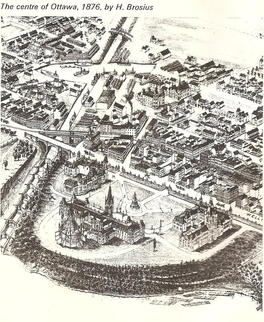
October 1, 2014: (added 1876 drawing by H. Brosius)
Picture Source: Early Days in the Ottawa Country, National Capital Commission, 1967, page 5
September 25, 2020:
Picture Source: Ottawa Waterway: Gateway to a Continent, by Robert Legget, University of Toronto Press, ISBN 0-8020-2189-I, page 113
A drawing from the Illustrated London News showing the 1860 Regatta behind the Parliament Buildings in celebration of the
visit of Prince Edward, the Prince of Wales.
 Keyword: Rideau Canal
RUSSELL HOUSE HOTEL, 1900

The downtown core of most major cities is an expression or imagining of its context as a
municipality and an urban center. For example, the downtown core in the city of Montreal
presents a different statement to outsiders than does Uppertown Ottawa. The center core of
the city of Ottawa reflects its status as a national capital and its imagining reflects the
evolving role of the federal government in terms of nationhood, which in turn influences
the architecture, landscaping, and cultural sense of the neighbourhood.
This paper will examine the development of the Uppertown area of Ottawa during two time
periods, pre-Confederation and post-Confederation. Within the post-Confederation timeframe
two factors will be shown to have had major impacts; Keynesian economics and the pressures
of two World Wars.
Uppertown is here defined as the area bordered on the north by the Grand or Ottawa River,
on the east by the Rideau Canal, on the south by Laurier Avenue and on the west by Bronson
Avenue.
Before Confederation:
Map Source: c. Al Lewis
 As can be seen on the above map, Barrack's Hill, now Parliament Hill, dominated the landscape
in the early days. The beginning of a small settlement at Richmond Landing (just below Chaudiere Falls) was soon surpassed
by the arrival in 1826 of the Royal Sappers and Miners under Colonel John By. They established
their administrative center on a strategic acreage on the cliffs above the Grand River, on
property which had been purchased by Lord Dalhousie. The Uppertown area of Bytown, west of
Barrack's Hill and north of Wellington Street was laid out by Colonel By in the late 1820's
in the grid tradition of the Georgian Town Plan. The main streets were Wellington, Vittoria (named after Queen Victoria)
(both of which still exist) and Cliff Streets. This land was leased to residents until the
federal government reclaimed it in the early 1900's. The early residents were mostly professionals
and gentlemen of commerce. These upper class Protestants were given leases "in perpetuity".
This encouraged the construction of high quality stone or brick residences. In contrast, most of
the lots in Lowertown, which were also located on part of Dalhousie's purchase, were leased for
a period of only thirty years, leading to the construction of wooden structures by the Irish
Catholic and French canal labourers who formed the majority in that area. From the first days
of Bytown there was a distinct separation between Lowertown and Uppertown; a distinction based
on ethnicity, religion and economic status.
Nicholas Sparks, from County Wexford, Ireland, who had previously worked for Philemon Wright,
owned a large parcel of land extending from and including the south side of Wellington Street.
Over the years he attempted to develop his property as the commercial and administrative center
of Bytown by establishing a market and civic buildings on his property. He succeeded in part;
but only later and then at the eastern section of his property, nearer to the canal than he had
originally planned.
In 1832 he donated land for the building of an Anglican Church, sanctioned by Archdeacon John
Strachan of York, near the western end of his property and overlooking Wellington Street. He had
previously given land to the Church of Scotland to build its church on Wellington Street at Kent
Street. Both of these original structures were stone, but modest by later standards. Sparks
created a market at Lyon Street and later built a civic hall close by. Gradually, lots were
sold on the south side of Wellington Street and a residential and commercial area appeared but
it did not attain the scale and commercial success of the Lowertown market and the steamship wharf
area. Uppertown continued to grow steadily before Confederation.
(new picture) June 29, 2005:
Thanks to Robert Sample for the following picture from
Looking Back, by Naomi Slater Heydon
The Nicholas Sparks Home
As can be seen on the above map, Barrack's Hill, now Parliament Hill, dominated the landscape
in the early days. The beginning of a small settlement at Richmond Landing (just below Chaudiere Falls) was soon surpassed
by the arrival in 1826 of the Royal Sappers and Miners under Colonel John By. They established
their administrative center on a strategic acreage on the cliffs above the Grand River, on
property which had been purchased by Lord Dalhousie. The Uppertown area of Bytown, west of
Barrack's Hill and north of Wellington Street was laid out by Colonel By in the late 1820's
in the grid tradition of the Georgian Town Plan. The main streets were Wellington, Vittoria (named after Queen Victoria)
(both of which still exist) and Cliff Streets. This land was leased to residents until the
federal government reclaimed it in the early 1900's. The early residents were mostly professionals
and gentlemen of commerce. These upper class Protestants were given leases "in perpetuity".
This encouraged the construction of high quality stone or brick residences. In contrast, most of
the lots in Lowertown, which were also located on part of Dalhousie's purchase, were leased for
a period of only thirty years, leading to the construction of wooden structures by the Irish
Catholic and French canal labourers who formed the majority in that area. From the first days
of Bytown there was a distinct separation between Lowertown and Uppertown; a distinction based
on ethnicity, religion and economic status.
Nicholas Sparks, from County Wexford, Ireland, who had previously worked for Philemon Wright,
owned a large parcel of land extending from and including the south side of Wellington Street.
Over the years he attempted to develop his property as the commercial and administrative center
of Bytown by establishing a market and civic buildings on his property. He succeeded in part;
but only later and then at the eastern section of his property, nearer to the canal than he had
originally planned.
In 1832 he donated land for the building of an Anglican Church, sanctioned by Archdeacon John
Strachan of York, near the western end of his property and overlooking Wellington Street. He had
previously given land to the Church of Scotland to build its church on Wellington Street at Kent
Street. Both of these original structures were stone, but modest by later standards. Sparks
created a market at Lyon Street and later built a civic hall close by. Gradually, lots were
sold on the south side of Wellington Street and a residential and commercial area appeared but
it did not attain the scale and commercial success of the Lowertown market and the steamship wharf
area. Uppertown continued to grow steadily before Confederation.
(new picture) June 29, 2005:
Thanks to Robert Sample for the following picture from
Looking Back, by Naomi Slater Heydon
The Nicholas Sparks Home
 After Confederation:
The City of Ottawa (incorporated in 1855) was made the capital of the united provinces of Upper Canada
and Lower Canada in 1841. The Barrack's Hill military center changed and became the parliamentary
precinct of the capital. Construction was begun on the Gothic style Center Block with its main
spire being the Peace Tower which housed the legislature and senate. Also, the East and West Block
buildings were erected to provide office space for civil servants. In 1867, with the addition of the
provinces of Nova Scotia, New Brunswick and Prince Edward Island, an additional wave of approximately
350 civil servants led to a requirement for more office space and residential accommodation and this
began to change the Uppertown culture. A more white collar and eclectic character emerged as higher
ranking civil servants gravitated to Uppertown while the lower level (mostly French and Irish Catholics)
settled in Lowertown. As well, the sawn lumber trade which was concentrated atChaudiere Falls was
developed by industrialists such as J. R. Booth and Erskine Bronson who had ties to Uppertown, and in
fact, had moved from Lebreton Flats to higher ground after the great fire of 1900. J. R. Booth (Booth Street), got his start in Ottawa business
circles by winning the contract to supply lumber for the construction of the Parliament Buildings.
Under the British North America Act, land use became a provincial responsibility. However the federal
government was permitted to acquire land and then, by "eminent domain" as the senior government, could do
as it chose with its own property. By using high levels of redundancy, i.e., by making its architectural
style unique and without equivalent, the federal government made a national statement. The Gothic
architectural style was considered to be the ultimate manifestation of heavenly aspiration and
coincidentally, Britishness. Usually the Gothic form has ecclesiastic implications but Ottawa was
influenced by the form of the houses of parliament at Westminster. Thomas Fuller won the contract to
design the Center Block and the Parliamentary Library. The Civil Gothic style won out over the Norman
style as the dominant architectural format of the capital of Canada.
In keeping with the Gothic theme and new roles as important churches within the national capital, all
of the major Uppertown churches underwent improvements. In 1873 a new building was constructed for Christ
Church (Anglican); a place which reflected Britishness and was suitable for worship by princes and
Governors-General. St. Andrew's (St. James) Presbyterian church was aggrandized and the Roman Catholics
built the ornate St. Patrick's Basilica on Nepean Street. The twin Gothic spires of Notre Dame Cathedral,
in Lowertown, were visible from the cliffs of Parliament Hill.
Also, by leaving prime land such as the lawns in front of the Center Block, vacant and available for high
level ceremony (i.e., Canada Day celebrations), the federal government left a lasting stamp of its presence
on Uppertown.
By 1879, Uppertown had taken on most of today's physical structure. The Sparks estate, which extended south
to Maria Street (later named Laurier Avenue) was surveyed into building lots. Wellington Street was a wide
promenade and the Uppertown market still existed at Sally (Lyon) Street. By the 1890's, innovations in the
distribution of electricity led to the use of streetcars on Bank Street and Wellington Street. As my
grandfather said (too often), "We didn't have to take the horse with the buggy behind". This advancement
in electrical energy use led to the development of elevators. This development, in addition to advances in
other technologies, such as structural steel framing, allowed buildings of more than four stories to be safely
built.
In 1899 the Ottawa Improvement Commission was created to beautify the capital, mainly by the use of landscaped
parks and was "dominated by the town, not the crown". It became the Federal Development Commission (FDC) in
1927 which had a stronger federal influence and included the mayors of Ottawa and Hull. In 1958 the FDC was
replaced by the present National Capital Commission (NCC) which is an entirely federal body with a large
budget and a central role in the planning of the The National Capital Region The NCC today owns almost all of the
waterfront property along the Ottawa and Rideau Rivers and the Rideau Canal.
The Parliament Buildings, c. 1910
Photo Source: Our Times, A Pictorial History of Ottawa's Past, page 75
After Confederation:
The City of Ottawa (incorporated in 1855) was made the capital of the united provinces of Upper Canada
and Lower Canada in 1841. The Barrack's Hill military center changed and became the parliamentary
precinct of the capital. Construction was begun on the Gothic style Center Block with its main
spire being the Peace Tower which housed the legislature and senate. Also, the East and West Block
buildings were erected to provide office space for civil servants. In 1867, with the addition of the
provinces of Nova Scotia, New Brunswick and Prince Edward Island, an additional wave of approximately
350 civil servants led to a requirement for more office space and residential accommodation and this
began to change the Uppertown culture. A more white collar and eclectic character emerged as higher
ranking civil servants gravitated to Uppertown while the lower level (mostly French and Irish Catholics)
settled in Lowertown. As well, the sawn lumber trade which was concentrated atChaudiere Falls was
developed by industrialists such as J. R. Booth and Erskine Bronson who had ties to Uppertown, and in
fact, had moved from Lebreton Flats to higher ground after the great fire of 1900. J. R. Booth (Booth Street), got his start in Ottawa business
circles by winning the contract to supply lumber for the construction of the Parliament Buildings.
Under the British North America Act, land use became a provincial responsibility. However the federal
government was permitted to acquire land and then, by "eminent domain" as the senior government, could do
as it chose with its own property. By using high levels of redundancy, i.e., by making its architectural
style unique and without equivalent, the federal government made a national statement. The Gothic
architectural style was considered to be the ultimate manifestation of heavenly aspiration and
coincidentally, Britishness. Usually the Gothic form has ecclesiastic implications but Ottawa was
influenced by the form of the houses of parliament at Westminster. Thomas Fuller won the contract to
design the Center Block and the Parliamentary Library. The Civil Gothic style won out over the Norman
style as the dominant architectural format of the capital of Canada.
In keeping with the Gothic theme and new roles as important churches within the national capital, all
of the major Uppertown churches underwent improvements. In 1873 a new building was constructed for Christ
Church (Anglican); a place which reflected Britishness and was suitable for worship by princes and
Governors-General. St. Andrew's (St. James) Presbyterian church was aggrandized and the Roman Catholics
built the ornate St. Patrick's Basilica on Nepean Street. The twin Gothic spires of Notre Dame Cathedral,
in Lowertown, were visible from the cliffs of Parliament Hill.
Also, by leaving prime land such as the lawns in front of the Center Block, vacant and available for high
level ceremony (i.e., Canada Day celebrations), the federal government left a lasting stamp of its presence
on Uppertown.
By 1879, Uppertown had taken on most of today's physical structure. The Sparks estate, which extended south
to Maria Street (later named Laurier Avenue) was surveyed into building lots. Wellington Street was a wide
promenade and the Uppertown market still existed at Sally (Lyon) Street. By the 1890's, innovations in the
distribution of electricity led to the use of streetcars on Bank Street and Wellington Street. As my
grandfather said (too often), "We didn't have to take the horse with the buggy behind". This advancement
in electrical energy use led to the development of elevators. This development, in addition to advances in
other technologies, such as structural steel framing, allowed buildings of more than four stories to be safely
built.
In 1899 the Ottawa Improvement Commission was created to beautify the capital, mainly by the use of landscaped
parks and was "dominated by the town, not the crown". It became the Federal Development Commission (FDC) in
1927 which had a stronger federal influence and included the mayors of Ottawa and Hull. In 1958 the FDC was
replaced by the present National Capital Commission (NCC) which is an entirely federal body with a large
budget and a central role in the planning of the The National Capital Region The NCC today owns almost all of the
waterfront property along the Ottawa and Rideau Rivers and the Rideau Canal.
The Parliament Buildings, c. 1910
Photo Source: Our Times, A Pictorial History of Ottawa's Past, page 75
 The character of capital cities is often influenced by high-level officials. Mackenzie King, as Prime Minister
from 1926 to 1930 and from 1935 to 1948, took great interest in the city. There had been a municipal government
presence in the form of a City Hall on Wellington Street at Elgin Street. When City Hall and the Russell Hotel
burned around 1929, there was an opportunity to develop an impressive promenade approaching Parliament Hill and
a memorial to veterans of World War I. The War Memorial was erected in 1939 and Confederation Square was created
with Elgin Street being widened as far south as Laurier Avenue.
The Influence of Keynesian Economics on Uppertown:
By the 1920's, the idea that governments could play a proactive role in the well-being of citizens was taking
effect. In 1936, John Maynard Keynes published The General Theory of Employment, Incomes and Money which,
during the latter part of the Great Depression became the working manual for a growing professionalization
of career economists. The gist of Keynesianism is that the government could use fiscal policy (control over
its revenues and expenditures) and monetary policy (regulation of interest rates and the money supply) to
keep the economy stable and growing, and thereby avoid great swings in unemployment. The origin of the
Keynesian movement in Canada was at Queen's University.
The main policy departments in the government of Canada rapidly expanded as a result of the Great Depression
and Keynesian economics quickly permeated the growing civil service.
The Department of Finance, under W. C. Clark, W. A. Macintosh and Robert Bryce as successive Deputy Ministers,
became very powerful. For example, in 1932, Dr. W. C. Clark changed the focus of the department from being
principally an accounting organization to being an instrument of national fiscal and economic policy and social
engineering. Note: My government career was spent in the Department of Finance ... Al.
Mitchell Sharp and Walter Gordon, both of whom started as civil servants and later became Finance Ministers,
exerted powerful influence on the government of the day. As well, the expansion in the bureaucracy between the
1940's and the 1960's resulted in the construction of many government buildings in Uppertown.
Once the departments expanded so that they were too large to be housed in the few government structures
originally built, there was much jockeying for position to be close to the Center Block. Being close to
the seat of power lent an air of authority to the departments, their Ministers and staff.
The Confederation Building, which had been built in 1929 on Wellington Street had been occupied mainly by
Department of Agriculture employees from its inception. The Department of Finance and its sidekick, the
Treasury Board Secretariat, eventually took over this building.
The Bank of Canada was incorporated in 1935 and had its own building erected by 1937 on the south side of
Wellington Street, across from the Confederation Building. The Department of Trade and Commerce was housed
in the East Memorial Building which was built in 1949 at the corner of Lyon Street and Wellington Street
where the Nicholas Sparks' Uppertown Market of the 1830's had been located.
As a result of the numbers of veterans returning from the wars, rational bureaucratic management and the
growth of the number of women in the labour force and economic and social policy initiatives developed in
the Department of Finance and the Bank of Canada, several government departments expanded dramatically. The
Department of National Health and Welfare was responsible for the Family Allowance and Old Age Pension; the
Department of Labour was responsible for Unemployment Insurance; and the Department of National Revenue was
tasked to administer the increasingly complex Income Tax Act. As well, the Department of Justice expanded to
advise Parliment on new legislation and regulations. Other departments that grew dramatically included the
Dominion Bureau of Statistics, now Statistics Canada) and the Deparment of Trade and Commerce.
The character of capital cities is often influenced by high-level officials. Mackenzie King, as Prime Minister
from 1926 to 1930 and from 1935 to 1948, took great interest in the city. There had been a municipal government
presence in the form of a City Hall on Wellington Street at Elgin Street. When City Hall and the Russell Hotel
burned around 1929, there was an opportunity to develop an impressive promenade approaching Parliament Hill and
a memorial to veterans of World War I. The War Memorial was erected in 1939 and Confederation Square was created
with Elgin Street being widened as far south as Laurier Avenue.
The Influence of Keynesian Economics on Uppertown:
By the 1920's, the idea that governments could play a proactive role in the well-being of citizens was taking
effect. In 1936, John Maynard Keynes published The General Theory of Employment, Incomes and Money which,
during the latter part of the Great Depression became the working manual for a growing professionalization
of career economists. The gist of Keynesianism is that the government could use fiscal policy (control over
its revenues and expenditures) and monetary policy (regulation of interest rates and the money supply) to
keep the economy stable and growing, and thereby avoid great swings in unemployment. The origin of the
Keynesian movement in Canada was at Queen's University.
The main policy departments in the government of Canada rapidly expanded as a result of the Great Depression
and Keynesian economics quickly permeated the growing civil service.
The Department of Finance, under W. C. Clark, W. A. Macintosh and Robert Bryce as successive Deputy Ministers,
became very powerful. For example, in 1932, Dr. W. C. Clark changed the focus of the department from being
principally an accounting organization to being an instrument of national fiscal and economic policy and social
engineering. Note: My government career was spent in the Department of Finance ... Al.
Mitchell Sharp and Walter Gordon, both of whom started as civil servants and later became Finance Ministers,
exerted powerful influence on the government of the day. As well, the expansion in the bureaucracy between the
1940's and the 1960's resulted in the construction of many government buildings in Uppertown.
Once the departments expanded so that they were too large to be housed in the few government structures
originally built, there was much jockeying for position to be close to the Center Block. Being close to
the seat of power lent an air of authority to the departments, their Ministers and staff.
The Confederation Building, which had been built in 1929 on Wellington Street had been occupied mainly by
Department of Agriculture employees from its inception. The Department of Finance and its sidekick, the
Treasury Board Secretariat, eventually took over this building.
The Bank of Canada was incorporated in 1935 and had its own building erected by 1937 on the south side of
Wellington Street, across from the Confederation Building. The Department of Trade and Commerce was housed
in the East Memorial Building which was built in 1949 at the corner of Lyon Street and Wellington Street
where the Nicholas Sparks' Uppertown Market of the 1830's had been located.
As a result of the numbers of veterans returning from the wars, rational bureaucratic management and the
growth of the number of women in the labour force and economic and social policy initiatives developed in
the Department of Finance and the Bank of Canada, several government departments expanded dramatically. The
Department of National Health and Welfare was responsible for the Family Allowance and Old Age Pension; the
Department of Labour was responsible for Unemployment Insurance; and the Department of National Revenue was
tasked to administer the increasingly complex Income Tax Act. As well, the Department of Justice expanded to
advise Parliment on new legislation and regulations. Other departments that grew dramatically included the
Dominion Bureau of Statistics, now Statistics Canada) and the Deparment of Trade and Commerce.

Two World Wars, External Affairs and Reconstruction:
In the 1890's the rationalization of large-scale manufacturing firms led to the adoption of scientific
management processes as conceived by Frederick Taylor. Society was undergoing a fundamental organizational
shift in economics and government by the beginning of the First World War. A cooperative effort between
industry and government during the war led to major growth in both private and public bureaucracies. In Ottawa,
this led to advancements in the areas of financial services to war veterans for pensions, retraining, and
housing. Icons of the wars flanked Uppertown; the Veterans Affairs Building to the west and the National
War Memorial to the east.
The Statute of Westminster in 1931 resulted in Canadian independence in foreign policy and an increase in
the number of employees in the Department of External Affairs. The Department of External Affairs, under
economist O. D. Skeleton, moved into the Langevin Block.
During World War II, an urgent requirement for additional office space led to the construction of temporary
buildings throughout Ottawa. In Uppertown one such building is still standing, on Vittoria Street, just
north of the Justice Building. A complex of temporary buildings was erected on Wellington Street between
the Supreme Court Building, built in 1939, and the present location of the National Archives Building.
C. D. Howe's new Department of Munitions and Supply occupied these temporary buildings.
The Justice Building, built in 1935, reflects architectural continuity with its neighbour the Confederation
Building. However, the West Memorial Building reflects the influence of the Second World War. It was built in
1955 to enable the rapidly expanding Department of Veterans Affairs to serve the welfare of many thousands of
returned veterans.
The federal government presents itself as friendly to the citizens of the nation. Serious and secretive
functions of policy formulation are balanced by public access to such institutions as the Canadian Currency
Museum. Tours are also provided to the Center Block, and the National Archives is open to the public for
historical research.
In the 21st century, the physical presence of the federal government in the National Capital Region is being
supplemented by its strong Internet presence. This modern tool has brought our capital city to all Canadians.
Summary:
The Uppertown neighbourhood in the city of Ottawa is dominated by the presence of the federal government.
The style and "permanence" of the buildings and the neighbourhood culture continue to differentiate it
from other sections of the city. The implementation of many of the recommendations of Jacques Greber, and
the strong interventionist role of the National Capital Commission and the Department of Public Works
continue to shape the capital of Canada.
Bibliography
Belden, H. and Company, Illustrated Historical Atlas of the County of Carleton, Including Ottawa, 1879, Toronto, Reprinted 1997 by Wilson's Publishing Limited
Bond, Courtney C. J., City on the Ottawa, National Capital Commission, 1964
Elliott, Bruce S., The City Beyond (Nepean): 1792-1990, 1986, Corporation of the City of Nepean, ISBN 1-55036-258-5
Fletcher, Katharine, Capital Walks, McClelland and Stewart, 1993, ISBN 0-7710-3151-3
Haig, Robert, Ottawa: City of the Big Ears, Haig and Haig Publishing Company, 1969
Hubbard, R.H., Cathedral in the Capital: A Short History of Christ Church Cathedral, Ottawa,
1972
Parliamentary Buildings Advisory Council Report, 2001, The Hill: Past, Present, Future
Taylor, John H., Ottawa, An Illustrated History, 1986, James Lorimer and Company
Publishers, ISBN 0-88862-981-8
Taylor, John H., Miscellaneous lecture notes from the Carleton University course in Canadian Urban History, (History 3209, Fall term, 2002)
Walker, Harry and Olive, Carleton Saga, Published by Carleton County Council, 1968
Woods, Shirley E. Jr., Ottawa, The Capital of Canada, Doubleday Canada Limited, 1980

One of the major streets in Uppertown was "Vittoria" which still exists today and runs
parallel to Wellington Street. The Murphy family from King's County, Ireland were early
residents of Vittoria Street. This family lived on Lot 43, Vittoria Street.
Temporary Building built to house war-time employees (WWII)
Located on Vittoria Street, immediately north of the Justice Building

The Confederation Building, built in 1929
North-west corner of Bank and Wellington Streets.
The first federal building west of Parliament Hill.
Most of the original employees were from the Department of Agriculture, reflecting
Canada's 90% rural population at the time.

January 18, 2011:
Old Ottawa City Hall on Elgin Street
Source for photo immediately below is From Ottawa With Love: Glimpses of Canada's Capital through Early Picture Postcards,
by Peter Hessel, published by the National Capital Commission, 1979, ISBN 0-660-50412-X, page 35
 The Supreme Court Building

St. Andrew's Presbyterian Church
 October 3, 2002:
Vision of Parliament Hill area in the future (graphic to be edited)
Source: Report of the Parliamentary Buildings Advisory Council, 2001
(Thanks Sheila-Marie !)
October 3, 2002:
Vision of Parliament Hill area in the future (graphic to be edited)
Source: Report of the Parliamentary Buildings Advisory Council, 2001
(Thanks Sheila-Marie !)

October 19, 2005:
Glashan Intermediate School was built in 1888 and renamed from the Hugh
Street School to Glashan in 1905.
May 29, 2008:
Rebecca, here is a map showing the extent of the By estate in downtown Ottawa. Barrack's
Hill is where our Parliament Buildings are today. The By estate was bounded by Maria Street,
now Laurier Avenue to the north, Bronson Avenue on the west (Concession Line Road on the map),
Gladstone Avenue to the south, and the Rideau River in the east.
Map Source: Ottawa, An Illustrated History by John H. Taylor, 1986, James Lorimer and Company,
Publishers, ISBN 0-88862-981-8, page 14

November 10, 2009:
Photo Source: Selections from Picturesque Canada: An Affectionate Look Back
plate number 34.
The Dufferin Bridge in Downtown, Ottawa
(A typical urban Victorian scene)
This sketch was made in the 1870's and shows a view from the east bank of the Rideau Canal.
The East Block of the Parliament Buildings is in the upper left.
In keeping with our lumbering history, there is a pointer boat carrying short logs, adjacent to the steam boat.
These logs may have been the source of fuel to run the steam engine.
February 5, 2010:
While in Ottawa, visit the Victoria Memorial Museum.
Image Source: Michael Flynn, sketch published
in the Ottawa Journal of March 13, 1976

March 8, 2010:
and another You Tube Video showing a panoramic view of Parliament Hill.
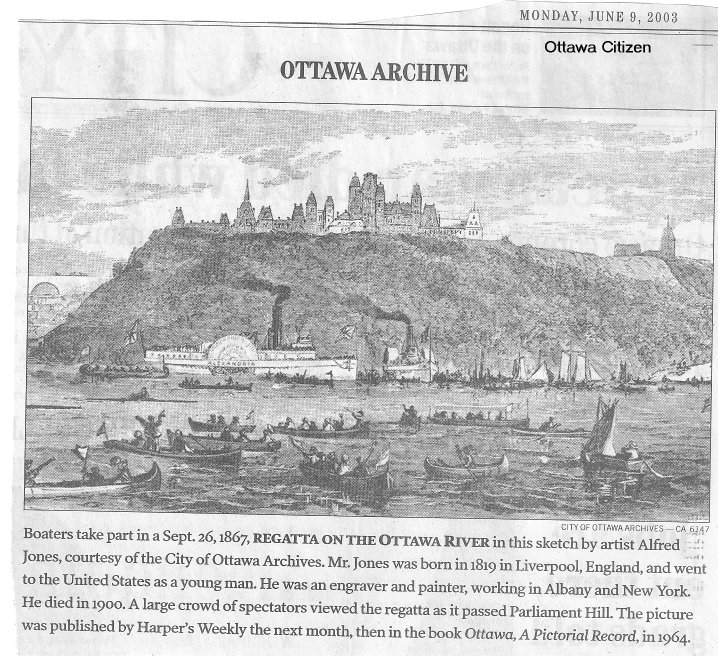
March 22, 2010:
Here are two scenes of the Parliament Buildings as seen from the Ottawa River.
The sketch on the left, by Alfred Jones, shows a regatta held on the Ottawa River in 1867, our year of Confederation.
The photo on the right was taken in 1898 from Nepean Point.

July 13, 2011:
Hi:
I recall my Great Aunt Ellen Burns telling me the Burns family first settled in Manotick when then came over from Ireland.
William James Burns also had a brother named Henry Burns who she said left to go out west around 1920 she thinks because she
remembers her mother saying goodbye to him and she was crying. She said they never heard from him again.
I found an article I copied that I thought you might find interesting. It's about Lovers Walk. You may already have seen
it but here it is:
WHEN PARLIAMENT HILL WAS FIRST LANDSCAPED IT WAS ENCIRCLED BY A LOVERS WALK. ONCE THIS QUARTER MILE PATH WAS A RETREAT FOR MEN
OF STATE AND LOCAL OTTAWANS WHO COULD, WITH A STROLL OF A HUNDRED YARDS, ENTER A REMOTE AND SILENT WOODLAND, ALMOST BEYOND
THE SIGHT AND SOUNDS OF THE CITY. PRIME MINISTER MACDONALD STROLLED HERE, AND LAURIER, BORDEN AND KING TOOK PLEASURE IN ITS
BEAUTY AND SOLITUDE.
UNFORTUNATELY, THE LOVERS’ WALK CAUSED UNEASE LEST THE GOVERNMENT BE HELD RESPONSIBLE FOR SOME MISHAP IN ITS SHADOWS. THERE WERE
RUMOURS OF DARK CRIMES AND IN THE 1930s THE AREA BECAME A HANGOUT FOR WHAT THE PRESS TERMED ˜UNDESIRABLE™.
THERE WAS ALSO SOME CONCERN THAT HUNGER MARCHERS MIGHT CAMP THERE. (The "On to Ottawa March"). WITH THESE THOUGHTS IN MIND
THE GOVERNMENT OF CANADA CLOSED ITS MOST FAMOUS PATH FOREVER, ALTHOUGH TRACES OF IT CAN STILL BE SEEN.
IN 1966, THE NATIONAL CAPITAL COMMISSION ANNOUNCED PLANS FOR A NEW WALK ALONG THE RIVER’S EDGE. WORK ON THE NEW WALK IS STILL
UNDERWAY BUT NEARING COMPLETION. BRILLIANTLY LIT, AND WELL-PATROLLED, SOMEHOW IT WILL LACK THAT VERDANT CHARM AND HISTORICAL
TRADITION OF THE OLD WALK. IT WILL BE A SAFE, SECURE, WALK FOR BOTH YOUNG AND OLD, WITH A FINE VIEW OF THE RIVER AND THE ˜NE
CITY OF HULL JUST ACROSS THE WATER.
NOTE: ABOVE ARTICLE WAS WRITTEN BY ERIC MINTON - A CITY RESIDENT SINCE 1923 – HE ALSO WROTE ˜OTATWAA REFLECTIONS OF THE PAS™ IN 1973.
HIS BOOK ‘OTTAWA – THE WAY WE WERE’ WAS WRITTEN IN 1974
Kaaren
September 7, 2011:
The Library of Parliament in 1872
Source: Parliament Hill, page 25, published July 1981,
by the National Capital Commission

April 22, 2019:
Next: Text and picture, below, is from National Capital Region, page 142
Library of Parliament


Estate)
