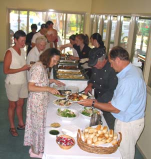
We spent a couple of weeks travelling not very far afield in the immediate Melbourne area, while staying at Kyneton Bushland Resort with Pat and George. Amongst other on-site entertainments was a so-called "Bush Banquet". Well, there weren't any wichitty grubs or lizard steaks or even kangaroo tail, but they certainly served a great buffet dinner once a week. The rest of the time we usually cooked in or ate out......
There was a fine swimming pool and then we borrowed a set of petanque balls for the occasional game amongst the wallaby poop deposits on the sparse grass. There were a few short bush walks we did occasionally but mostly we explored the immediate neighbourhood, about 3/4 hour drive N. from Melbourne. One day there was a giant Classic Car rally not too far away, so we visited this for the day to admire all the impeccably maintained ancient and interesting automobiles, several thousand of them, gathered together at the horse race course at Hanging Rock. This is a volcanic escarpment standing a couple of hundred feet above the surrounding plain and named for a giant chockstone under which you must squeeze in order to attain the summit. Hanging Rock is also notorious as the place where two school girls disappeared many years ago with no trace. They were part of a school party and at least one other member turned up after some time with no memory of what had transpired. There was the usual drama-documentary film made about the whole mystery. But that wasn't of any relevance to the thousands of spectators drooling over all those automobiles - classics, dragsters, ingenious, high-powered, lovingly restored and maintained. Nevertheless even the untrained eye could detect a few anachronisms in the dozens of restored MGAs and TR2s......
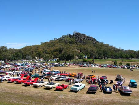
Hanging Rocks in the background, a few of the exhibits in the foreground.
Yours truly made a quick ascent to the top of the rocks, just to take a look at the Hanging Rock itself. And to fossick around for any skeletons, too, I suppose. My verdict - it would be an easy place to fall off a cliff and bust your head in, fall into a crevice and never be seen again.
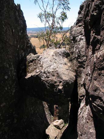
The giant chockstone - Hanging Rock.
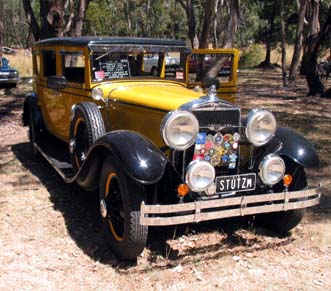
It took 12 minutes to make the ascent, 10 more minutes to come down again and a further 30 minutes to recover while quaffing a few beers. Then, back to all those cars. The favourite car of the true-blue Australian is of course the Holden - only car made in Australia - and the way to raise his ire and cause a ruckus is to suggest that it's inferior to a Ford. Well, I could show you almost 100 pictures of all the cars on display but one of the finest was this Stutz. You could imagine Marlene Dietrich stepping elegantly out of this vehicle in 1930s Berlin intent upon stealing secrets from the Reich Chancellor....
Take a look at those Rally Badges - not good for the radiator !
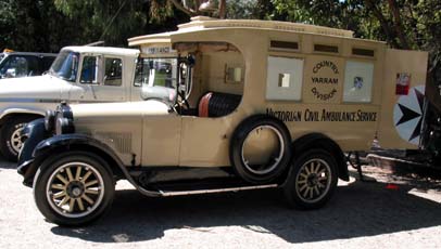
Or perhaps you might like to imagine Robert Donat, stiff-upper-lipped, careening through no-man's land on the Western Front and ignoring the shells and machine gun bullets on his mission to save lives in this beautifully-maintained ambulance from a rather earlier era....
We made a long day's expedition to see the Great Ocean Road, that stretch of highway, west of Melbourne and Geelong, which is continually being eroded by the battering of the Southern Ocean whose predominantly E. driven waves are squeezed into the Bass Strait between mainland Australia and Tasmania. The sandstone cliffs are hacked into wonderful pillars and bridges - at least one of the major pillars had fallen since we were last here, part of a group known as The Twelve Apostles. I wonder if they will now be renumbered as The Eleven Apostles. Good name for a cricket team I think.
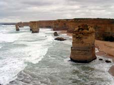
The (late) 12th Apostle is that heap in the centre - its fall was recorded by a lucky tourist with a videocam.
Needless to say, this coast is another of those ship-graveyards which are found on lee shores all over the world - clipper ship captains would be thundering on with all sails in the attempt to beat their rivals to the valuable cargoes of Melbourne and Sydney with perhaps little accurate knowledge of their position after their weeks in the Roaring Forties and would miss even such prominent lighthouses as this one, right at the tip of this great peninsula. Cape Otway Lighthouse is now inactive but is preserved, together with the adjoining Telegraph Station which had a very much shorter working life - the undersea cable to Tasmania lasted only a few months and wasn't relaid.
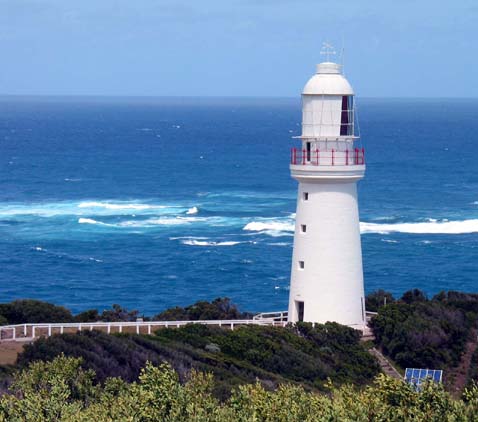
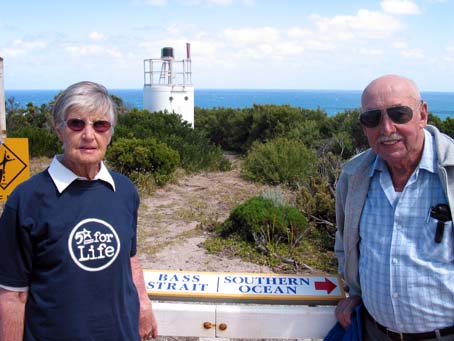
This lighthouse is actually at the official junction of the Southern Ocean and Bass Strait. Three years ago we had sent you a photo of us at the point, a few thousand km W. of here where we had found the junction of the Southern Ocean with the Indian Ocean. Here's Pat and George at this new location - once again, if you look very carefully, you may be able to make out the dotted line in the sea which the mapmakers put there to mark the junction of these two bodies of water. The little tower in the background is not the old lighthouse nor even the WW2 radar station but their modern high-tech replacement.
If you look at a map you will surely realise that this was one of the longest of our daily outings, 650 km in all. Most of the time we visited only places in the immediate area. Castlemaine is one such, a sizeable town, not too far from Kyneton, which was another of the gold rush places of the late nineteenth century, bearing the distinctive stamp of the young Queen Victoria in its architecture. Here's a picture of the high-tech of those days - one of the last of the muzzle-loading cannons, but not one of the old-fashioned smooth-bore type, this one being equipped with a steel, rifled liner.
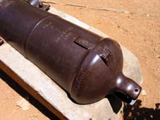
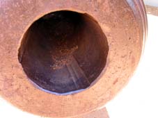
Cannon, dated 1861, showing the rifling of the barrel.
We found a fascinating store on Castlemaine's main street - The Builder's Hardware was a gigantic hardware store-cum-garage sale-cum-museum which was stuffed with every possible sort of recyclable - er - junk, the sort of stuff which you'll find in a billion basements and garden sheds throughout the known universe. Wish we had had a year or so to browse in detail. Castlemaine is also the place where a remarkable feat of marine salvage was started. Although far from the sea, it was the town that made a remarkable diving bell in the late forties. The ship "Liverpool" was mined while carrying 60M in gold bars from New Zealand to Vancouver en route to the U.S., the gold as WW2 munitions payment. Lying at about 250', the salvage was considered too deep for normal deap-sea diving (apart from other considerations, such as WW2) but nevertheless Captain Jack Smith of Caslemaine mounted an arduous six-month salvage effort to cut into the ship's strongroom and bring the gold bars up to the surface, all by surface-controlled devices directed by the occupant of the diving bell supplied with a maximum of ten hours air and carbon dioxide scrubbers, i.e. no pressurized air supply at all. Three of the bars (apparently) were unrecovered so I guess they're still at the bottom if you want to have a go. The original diving bell, made of bronze, so it hasn't rusted, is in the Castlemaine museum so you may perhaps be able to persuade the town to lend it to you.
It was time to move on in mid-Feb. We went for a couple of days to Philip Island to look at the tiny penguins there and then delivered Pat and George to Tullamarine airport, Melbourne, on their way home while we travelled further W. toward Robe, South Australia. Robe is nowadays a small tourist town, but in its day it was famous or possibly infamous as the port, conveniently far from both Adelaide and Melbourne where Chinese immigrant gold-seekers could land and avoid the crippling ten pound head tax imposed by the fat cat bankers of Melbourne. From Robe to the gold fields is a cool 250 km walk over country poorly supplied with water or any other form of succour - consider moreover that the travellers usually would have to carry their tools, goods, shelter materials, food and drink, usually pushed in a wheelbarrow.
On our way W. we made an extemporized stopover at a roadside rest area at Mannum Falls. There are hundreds of these roadside stopovers throughout Australia, places where you can very often camp overnight for free and certainly you can sleep overnight even if you're not, technically, camping. This is all part of the Australian urge to promote safe driving, i.e. to avoid long long hours at the wheel -"Rest, Revive and Survive" - "Don't let a deadline make you dead" and the like. Mostly these roadside stops are too close to highways for comfort but Mannum Falls is one of the exceptions - they are listed in a booklet which is well worth its price, by the way.
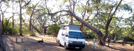
Camping at Mannum Falls, a great little stopover.
Mannum Falls and a dryish whirlpool pond, but take a look into that undercut cavern under the dry fall !
There was a minor setback at Mannum Falls where I inadvertently left my beloved red hat after taking it off so I wouldn't drop it over the edge ! We had a second setback on the way to Robe - first, about 20 km beyond Mount Gambier, only sizeable town on the route, a tire exploded. Changing a tire isn't a difficult problem but the problem became an annoying one when we found the spare wheel had been fobbed off on us with a wrecked tire upon it - the outer tread had stripped leaving a 4" wide hole, bare inner tread and broken wires beneath. With this we limped back toward Mount Gambier before it became too dangerous to travel any further. Here the wonderful generosity and friendliness of Australia came forth - many thanks to Steve, who not only gave us a lift to Mount Gambier twice (once to replace the faulty spare, the other to replace all of the other tires) but also used his first-hand knowhow of the tire dealers to get us a good price for the four tires needed. We knew the tires would have to be changed but were holding off as long as possible. Thanks to Steve, we were delayed only a little more than an hour for the whole thing but we elected to travel onward to Beachport and then stay overnight just to ensure the tires didn't develop leaks within that period.
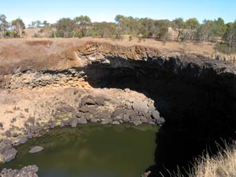
Mount Gambier has a unique water supply. The town is built on and around a long-extinct volcano, whose caldra has tapped into the continental water table. The resulting lake is very deep and moreover is one of those strange "blue" lakes which are also frequent in Tasmania and which develop their blue colour seasonally, suddenly in Nov./Dec. to their brilliant blue and, equally suddenly, in Mar./Apr. to a restrained grey tone.
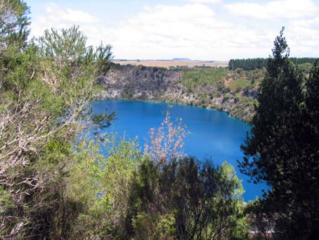
The crater is about a mile across and this picture doesn't give a true sense of the way in which the water seems to glow blue. Incidentally, the water level has fallen about 2 metres over the past hundred years' usage. When the volcano originally exploded, the surface and subsurface rocks were thrown to enormous heights and distances. These 'bombs' then fell into the volcanic ash which then compacted around them, preserving them much as were the bodies at Pompei. The arrows below point to three of these 'bombs' revealled by the road cutting: white limestone/dolomite; black basalt and reddish granite, embedded in an ash matrix - actually, in the picture above you can see lots of white dolomite 'bombs' on the opposite wall of the crater.
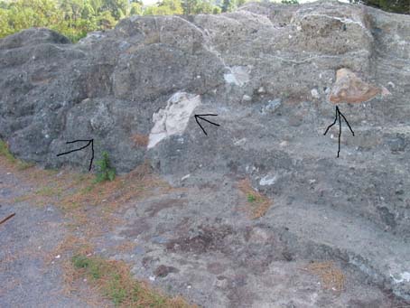
Sorry about the crude arrows - I've just noticed a better basalt example, top, small, above the righthand arrow.
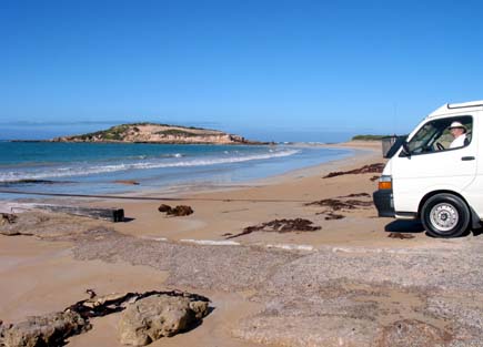
Finally, even though a day later than planned (planned ? what's that ?) we got to Robe. Had half a mind to do a bit of 4WD on the beach there just to see if Gertie II could make it but Shirley-Anne persuaded me not to risk it. Here they both are, poised on the edge of the beach, with Gertie, at least, looking ready to have a go.
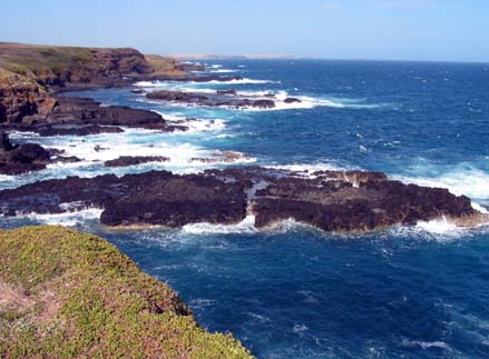
The mild appearance of the sea here is a bit of an illusion. Robe is a very well-sheltered port, but not too far away, just over that peninsula which harbours the prison, by the way, is a rough-looking sea. The rock here isn't as soft as the sandstone around Melbourne but it still gets carved into fantastic shapes, caves and blowholes.
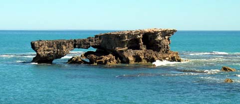
This is Doorway Rock, seen from Robe Gaol. There are big sharks down there, waiting for would-be escapers.
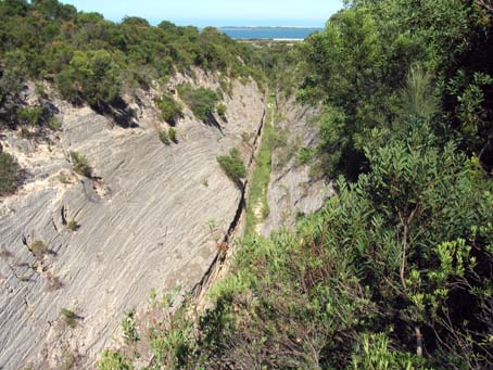
We didn't stay in the town of Robe itself, but a few km S at Sunland Holiday Village, Australia's only ocean-front nudist resort with its own (legal) nude beach. We stayed here for a few days to have a little sea-bathing and also to walk along the 5 km long beach, meeting no-one except, once, a 4WD party trying to go as fast and as noisily as possible. Here in Beachport, posted the back-up cd for Frank, ve3yy, to replace this web page. If you can't read this, then he didn't. Third setback here - left a vital brief case, containing all the important travel documents, personal data etc in the post office and so we had to return the next day (over gravel cordoroy roads in order to get it back. Halfway between Robe and Beachport is a very interesting site. The country here is all flatlands, sand dunes and salt marsh. One of these marshes had been hemmed in by a high dune system and, though no longer salted, the water drainage had been prevented because of the clay silt layer which had then settled. Wonderful farmland, if you could only get the excess water off it and drain the marsh. That's an unusual problem in Australia of course. Two men, the owner of the land and his only assistant, spent three years in cutting an enormous drain across the intervening barrier, successfully drained the marsh and liberated many hundreds of fertile acres. They used three machine tools - a large caterpillar tractor, a big dragline bucket and a marshplough. The cutting is about a hundred feet deep, equally wide and about 5 km long overall. The drain is the narrow slot at the very bottom of the much wider vee-shaped cutting, looking down to the distant sea.
At Sunland, no Web Page, but email sunland@seol.net.au is a wonderful place to visit for deserted sand dune walks. It's a good idea to take a gps along with you or at the very least a compass if it should happen to be a (rare) cloudy day with no sun sights because you could easily get lost amongst all those sand dunes - needless to say, carry plenty of water, too. It's also an excellent place to study the reclaiming of sand dunes by use of natural vegetation - the owners have done a great deal of work in setting this process up. And the daily 'happy hour' at 5 pm was wonderful.
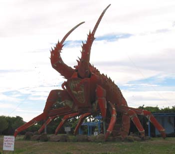
We continued up the Prince's Highway toward Adelaide. The coast here is flat and sandy and eventually the seaward dunes become joined into a long promontory, trapping the sea into a dead-ended sort of estuary, unsupplied with fresh water and so forming a high-salt lake, good for crayfish and lobster fishing and, one supposes, the long-ago smuggling of Chinese illegal immigrants. Although we had decided against collecting the "Big Things", Australia's answer to N. America's Burmashave posters, we thought Canadians, particularly Maritimers, would appreciate the Kingston SE Big Lobster. Not much in the way of claws though. And, hey, there will be a small prize for anyone who can tell me why Kingston, in SA, is called "Kingston SE".
More than a week ago we arrived at Tindo www.tindonudistclub.com.au and here we've met many old and new friends. It's been almost three years since we were last here and it seems like yesterday. The weather is becoming cooler but the swimming pool welcomes daily and we've had only one day's rain in the past week, i.e. the temp is A-OK. Some of the things we've done - well, of course we have been on at least one day's wine-tasting drive around the Barossa Valley. Here is one of the fabulouse palm tree avenues in the village of Seppelfield, home of the fabulous Tokay Wine (at over $1000 the bottle it had better be fabulous, but we didn't buy any).
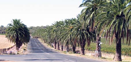
Hundreds of acres of wonderful grape vines behind those palm trees.
Another day, we went to see the Barossa Reservoir. This is not perhaps a normal reservoir, collecting run-off water from a surrounding watershed. It is used to store water pumped from the Murray River, one of the few large rivers in Australia and used for irrigation throughout its meandering length (one of the longest navigable rivers in the world) and particularly important in Victoria and South Australia, the main fruit-growing states. The Barossa Reservoir is held back by a very high dam, the first major concrete dam in the world, renowned locally for a different matter. Because of its shape, catenary in two dimensions I suppose, it acts as a sound intensifier. Stand at one end and you can whisper the most indecent suggestions to a young lady standing at the other and you'll have plenty of time to get away before she calls her father. Too bad if he's on a mobile (cell) 'phone and turns out to be waiting for you in the parking lot - be aware of that hazard.
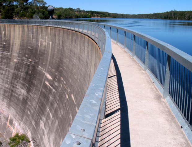
The Whispering Wall at Barossa Reservoir - 100+ years old.
We've been at Tindo now for over a week and tomorrow we'll set off, up the Murray River Valley, on our way back E. Maybe we shall call in at Wagga Wagga, just to see if it really exists.....