Homo sapiens was born on the high dry savannah of Pliocene Africa. Wetlands were there the abode of man-eating crocodiles, forests the home of man-eating leopards. Our biological roots are deep - most people still instinctively view wetlands as foreboding places of disease, and deep forests as depressing places of insecurity. The combination, a wooded swamp, seems unthinkable! But, unknown to humans throughout most of our history, the health of the earth's biosphere, which we require for life, depends more on wetland and forest than on our native open field.
Wetlands provide essential habitat for a third of all Canadian bird species, 204 of the 578 by one count. At least 50 of our mammal species require wetlands for their survival, probably a thousand species of plants. A healthy marsh has hundreds of times the biodiversity of a hay or wheat field the same size, and grows three times as much plant material too. To the environment ministers of the United Nations, "The biological diversity that comprises variability of genes, species and ecosystems is the world's most valuable resource for the sustainability and welfare of all humankind."
Yet, throughout southern Ontario, we have destroyed at least 75% of the wetlands that were here before European settlement, in south-western Ontario close to 90%. And, we are still destroying them as if we would make no tomorrow. So, it is essential to human survival that we overcome our biological bias.
Near the little settlement of Leitrim, in eastern Ontario, there was a small remnant patch, 400 hectares, of the old neutral-to-alkaline wetland that used to cover most of the Ottawa area. It seems to have been wetland since the glaciers retreated, it has never been cultivated. Most of the peat is of a depth requiring over a thousand years to deposit. The water table was lowered about a metre during the 1920's by adjacent agricultural drainage, which allowed some of the peat land to oxidize, but most remains intact. Drainage since 1920 has also destroyed most of the fen habitat of the site, but enough remains to rejuvenate the original area. The area harbours many of the oldest trees of the region - white pine a metre in diameter, 250 year old larch, 200 year old cedar and elm - and their successors down to seedling age. As a biological island into which remnants of once-plentiful wetland-dependent plants have been forced, it is botanically among the most biodiverse patches of eastern Ontario. It has more species of regionally-significant plants than the federal government's local RAMSAR showpiece, the Mer Bleue, in only a tenth the area.
It is being destroyed.
A housing development is being built on the very lowest portion of the wetland. The houses have full basements, which require that the water table be lowered 2 metres more than at present all around the north and east of the wetland. And, in what seems difficult to believe is not a deliberately destructive decision, a storm water pond has been built immediately adjacent to the area to be conserved, in the old drainage channel, a full 4 metres below the present wetland water table. The storm water from the housing area which presently flows through the center of the wetland is to bypass it and be dumped into this pond. Every level of government, federal, provincial, regional, and municipal, has been persuaded to approve the project, despite the existence of many square kilometres of land immediately to the south that is much better suited for housing: marginal farmland, of almost no ecological value, and well drained.
The patch shown in yellow has been transferred to the South Nation Conservation Authority to be protected as wetland. In order to protect the wetland water table, a sheet steel barrier, of 'expected' lifetime 100 years, is proposed to be driven into the ground between the storm water pond and the wetland. (The engineers offered another option, a thin layer of clay held in place by fabric, which would last only until the first groundhog got busy.) The size of the barrier is based on the 'most probable' permeability of the surrounding soils and rock, meaning that there is a 50% chance that it is adequate, a 50% chance that it is inadequate. In the words of the engineers, "It is not considered appropriate to select the most conservative test value for analysis, but rather to use a representative value ... estimates obtained for glacial till at the Leitrim site range from 6300 nm/s to 34 nm/s ... the selected value of 500 nm/s is considered reasonable" And, they assumed the permeability of the underlying rock to be zero.
If a '50/50' decision is made every 50 years, the chance that the wetland will survive even the next 1000 years is only one in a million. (50% after 50 years, 50% of 50% = 25% after 100 years, 12½% after 150 ...) We need to make decisions appropriate for something that has lasted 8500 years for places like Leitrim. Requiring that 50-year decisions on Leitrim have a 99.6% probability of being right is not being conservative - that still only gives the site a 50/50-overall chance of surviving as long as it already has.
In fact, the chance that the chosen permeability is adequate is much less than 50% in this case.
1. About a kilometer away, at the site of a large garbage dump, a test drilling was done a few years ago to determine the permeability of the underlying rock. The first hole hit fractured rock, and gave a permeability so high that the dump would have had to be closed. So, the firm involved drilled another one, which hit only unfractured rock and hence gave the answer desired. Then, they invented a reason why the first drilling should be ignored. More recently, a 1998 report by Water Technology Int'l. Corp. for Transport Canada on the dump was more honest: "extensive fracturing was noted within bedrock cores retrieved ... the bedrock ... may exhibit significant hydraulic conductivity properties and may therefore be acting as a major preferential flow path ..."
2. The permeability of a soil layer is not a simple fixed figure. The value used by the engineers is based on compacted material. When a hydraulic head of 4 metres, which is what the engineers are proposing to apply, is applied to less than 4 metres of soil, the permeability increases, dramatically - the soil is pushed aside or even fluidized by the upward-welling water.
3. There is a large area at the north end of the wetland (marked U on the air photo) where deep upwelling is occurring within the Leitrim wetland - subterranean water from the south wells up on the north side of the ditches dug last century to such an extent that agricultural drainage of that section was abandoned, even though the hydraulic head there can not be much more than 1 metre, if that.
4. The ancient water flow from west to east was interrupted many years ago when Albion Road (the nearly-vertical road half way between the two red arrows at right) was upgraded and culverts removed throughout most of its route through the wetland. The water still flows, however - the blocked drainage is marked by a solid wall of buckthorn (an alien species, that grows here where the growth of native species is impaired). 50 m in from the road, small rivulets begin appearing, and by 100 m, the forest floor is pretty well back to normal wetland health. That water is all coming from underground, from where the engineers claim water cannot flow.
Data released as a result of the Canadian Environmental Assessment Act process conducted by the federal Department of Fisheries and Oceans, validated this analysis, and many recognized experts put concerns such as mine on record. Dr.W.K.Nuttle, of the Canadian Wildlife Service, was on record by 1995, but his concerns were brushed aside. Then he was joined by Dr.C.Topp of Agriculture Canada, Dr.F.Michel of Carleton University, and Michael Loewen P.Eng. who did postgraduate studies on the Gloucester Landfill site. All consider that the conductivity of the site was greatly underestimated by Tartan's consultants. (By the way, all these experts defending the wetland served with no fee. All those supporting development were paid in full by the developers.) The final report, by Natural Resources Canada, also essentially confirmed Dr. Nuttle's assessment.
In a meeting with Barry Lithwick, one of the developers, I suggested a process by which the wetlands might be saved to be named after his grandfather who founded the family fortune - at that time the wetlands had no official name according to the Geographical Names Board of Canada. But, I got a glimpse into the private Ottawa power scene when Lithwick phoned Wes Nicol of Tartan to suggest that he talk to me as well. Zero talking. Zero compromise. Don't you dare go soft on us.
Where is it? Just 20 minutes from Parliament Hill.
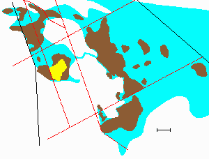
The wetland area the way it was. The brown areas are deep peat, the blue (and brown) was
wetland as late as 1830. Black lines are railways, red major roads. The yellow portion, barely a
kilometre square, is all that is planned to be left in a few years.
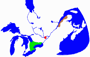 The Canadian extent of Carolinian fens supporting the plant community typified by Marsh
Valerian and White Camas is shown in green. These fens also contain Cottonwood, False Nettle,
and Nannyberry. The Atlantic fens supporting the Marsh
Valerian and White Camas community are restricted to the brown area -
they also contain Limestone Oak Fern, Whorled Wood Aster and Twisted Stalk. The fen in the
Leitrim wetlands, greatly enlarged in red, is the only place in the world where these two plant
communities overlap - it contains all of these species.
The Canadian extent of Carolinian fens supporting the plant community typified by Marsh
Valerian and White Camas is shown in green. These fens also contain Cottonwood, False Nettle,
and Nannyberry. The Atlantic fens supporting the Marsh
Valerian and White Camas community are restricted to the brown area -
they also contain Limestone Oak Fern, Whorled Wood Aster and Twisted Stalk. The fen in the
Leitrim wetlands, greatly enlarged in red, is the only place in the world where these two plant
communities overlap - it contains all of these species.
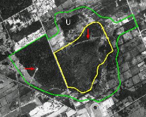
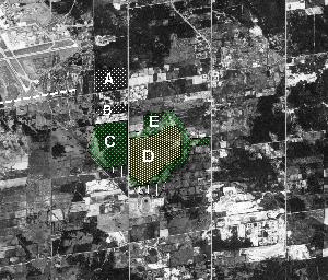
The wetland from the air. The green line is the protection boundary recommended by the
Canadian Wildlife Service in 1993, the yellow the current plan. The horizontal red arrow shows
the new radar site, the vertical arrow the developer's drainage ditch. The green boundary is
120 metres outside the average wetland boundaries defined independently by the Ontario Ministry
of Natural Resources in 1989, by the consulting firm Cumming Cockburn Ltd in 1990, and by
botanist Albert Dugal of the Canadian Museum of Nature in 1990. The white U marks a known
area of upwelling water.
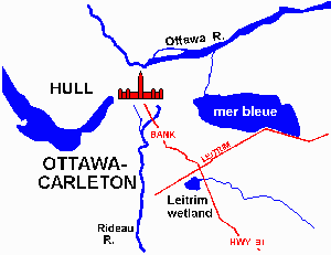
The location of the needed new Ottawa Airport runway (the dotted line to the left)
and the housing development (block A). D has been transferred to South Nation Conservation.