Dow's Lake, Hartwell's Lock and Hog's Back, Ottawa, Ontario, Canada
(Formerly Dow's Great Swamp)

 May 18, 2021:
Picture Source: From War to Winterlude, 150 Years on the Rideau Canal, By Mary E. Peck,
ISBN 0-660-51015-4, 1982, page 37.
Appearance of the Dam at Hog's Back After the Breach has been repaired, October 18, 1832
Keywords: By Admiral Henry Byam Martin (1804-1865), Library and Archives Canada, Picture Division Negative Number C-115005
May 18, 2021:
Picture Source: From War to Winterlude, 150 Years on the Rideau Canal, By Mary E. Peck,
ISBN 0-660-51015-4, 1982, page 37.
Appearance of the Dam at Hog's Back After the Breach has been repaired, October 18, 1832
Keywords: By Admiral Henry Byam Martin (1804-1865), Library and Archives Canada, Picture Division Negative Number C-115005

May 17, 2021:
Picture Source: From War to Winterlude, 150 Years on the Rideau Canal, By Mary E. Peck,
ISBN 0-660-51015-4, 1982, page 35.
Appearance of the Dam at Hog's Back After the Breach Took Place, April 3, 1829
Keywords: Lieutenant Colonel John By

March 5, 2021:
Falls at Hog's Back, 1892
Picture Source: The Rideau: A Pictorial History of the Waterway, Edited by Adrian G. Ten Cate, Besancourt Publishers,
ISBN 0-920032-04-4, 1981, page 146.

February 20, 2021:
Here is a current map showing the high-rise towers at Hog's Back today.
Picture Source: The Rideau: A Pictorial History of the Waterway, Edited by Adrian G. Ten Cate, Besancourt Publishers,
ISBN 0-920032-04-4, 1981, page 8.
 If you go down to April 30, 2020 on this page you will find a map for 1847. This map gives the names of many Rideau Canal
workers who built the Hog's Back Locks and the dam. Most of them had been there since 1832 when the canal construction was completed.
However, many of them were second generation by 1847 - my GreatGreat Grandfather was still there although he had bought farmland
on the Manotick Station Road. Eventually the authorities pushed these families along.
If you go down to April 30, 2020 on this page you will find a map for 1847. This map gives the names of many Rideau Canal
workers who built the Hog's Back Locks and the dam. Most of them had been there since 1832 when the canal construction was completed.
However, many of them were second generation by 1847 - my GreatGreat Grandfather was still there although he had bought farmland
on the Manotick Station Road. Eventually the authorities pushed these families along.
November 19, 2020:
The Wooden Tug Boat Shanly
Photo Source: Invisible Army: Hard Times, Heartbreak and Heritage, by Ed Bebee, ISBN 978-0-9696052-4-9, page 207

I believe that Frank Nevins was a neighbour of my Grandparents in Osgoode Township. ... Al
November 19, 2020:
The Tug Boat Loretta at Hartwells Lock in 1940, across from Carleton University
Photo Source: Invisible Army: Hard Times, Heartbreak and Heritage, by Ed Bebee, ISBN 978-0-9696052-4-9, page 165
 Keywords: Workers on the Rideau Canal, Steamer Loretta at Hartwells Locks, steam boats
Mike Egan, Harry James, Jack Forrester, Oliver Seguin, Steve Hayden, Russ Quigg, J.E. Forrester, Steel Hull in 1907
Keywords: Workers on the Rideau Canal, Steamer Loretta at Hartwells Locks, steam boats
Mike Egan, Harry James, Jack Forrester, Oliver Seguin, Steve Hayden, Russ Quigg, J.E. Forrester, Steel Hull in 1907

April 6, 2008:
Dow's Lake was created by Rideau Canal workers under the engineering management of
Colonel John By and his Royal Sappers and Miners. One of the most difficult areas of
canal construction between Ottawa and Kingston, Ontario, was the stretch between the
Ottawa River (6 locks in step where the Rideau River empties into the Ottawa River) and
what is now called Hog's Back, just south of Carleton University.
When Colonel By was surveying to find the easiest route to build the canal between
the Ottawa River and Hog's Back, there were two apparent options. The first was to
join the Ottawa River to Hog's Back by cutting the canal from the Ottawa (or Grand)
River, above the Chaudiere Falls and along Preston Street to where the boathouse
is today on Dow's Lake.
It was decided that an easier route would be to start the Canal at Entrance Bay,
which is on the Ottawa River just east of the Parliament Buildings, a dam was built
at the end of Preston Street to raise the water level of Dow's Great Swamp and at
the same time to drain the swamp / creek which existed along what is now Preston
Street. The dam was called the St. Louis Dam after Jean-Baptiste St. Louis who was
one of the pioneer French Canadians to settle in Bytown.
May 18, 2008:
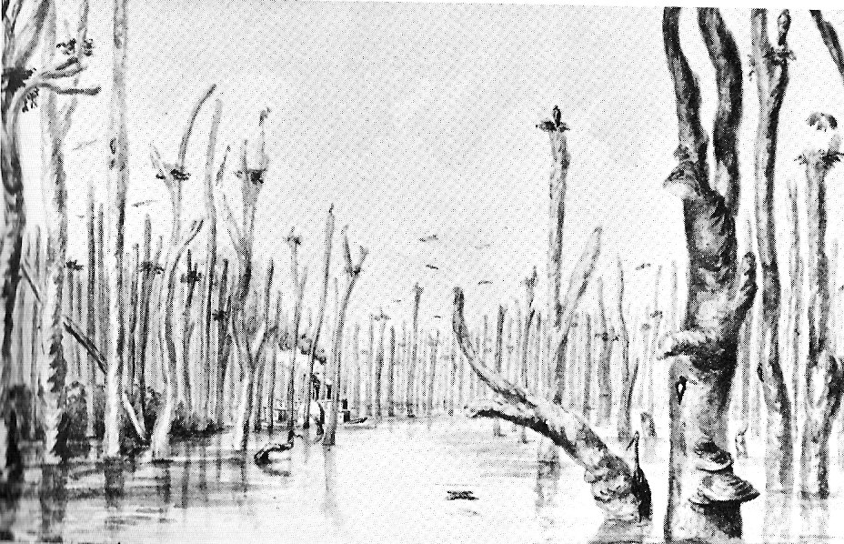
About 1830, John McTaggart sketched Dow's Great Swamp. If you look closely at his drawing
below, you can see one of the first paddle-wheelers on the lake. This steam powered boat
had the wheel on the port side of the boat. There was probably also a twin wheel on the
starboard side.
Photo Source: Ottawa: City of Big Ears, by Robert Haig.
 John McTaggart's classic book is available in digital format. It's called
Three years in Canada: an account of the actual state of the country in 1826-7-8,
Comprehending its resources, productions, improvements and capabilities, and including
sketches of the state of society, advice to emigrants, &c.
MacTaggart, John, 1791- c. 1830. (McTaggart)
362 pages, (London : H. Colburn, 1829.)
There is a surveying-type map at the National Map Collection of Library and Archives
Canada showing the original swamp along Preston Street between Dow's Lake and the
Ottawa River. Map Number NMC 0016824 from the National Map Collection.
Preston Street is now the home of Little Italy in Ottawa.
The following two sketches show Hog's Back in 1832.
The top sketch was done by William Clegg. The next sketch was by Thomas Burrowes.
Photo Source: Ottawa: City of Big Ears, by Robert Haig.
John McTaggart's classic book is available in digital format. It's called
Three years in Canada: an account of the actual state of the country in 1826-7-8,
Comprehending its resources, productions, improvements and capabilities, and including
sketches of the state of society, advice to emigrants, &c.
MacTaggart, John, 1791- c. 1830. (McTaggart)
362 pages, (London : H. Colburn, 1829.)
There is a surveying-type map at the National Map Collection of Library and Archives
Canada showing the original swamp along Preston Street between Dow's Lake and the
Ottawa River. Map Number NMC 0016824 from the National Map Collection.
Preston Street is now the home of Little Italy in Ottawa.
The following two sketches show Hog's Back in 1832.
The top sketch was done by William Clegg. The next sketch was by Thomas Burrowes.
Photo Source: Ottawa: City of Big Ears, by Robert Haig.
 Map 1, below, is taken from Dr. Bruce Elliott's book Nepean: The City Beyond.
This map shows Dow's Lake in 1847. By 1847 there are some settlers shown around the
lake and extending past Hartwell Locks as far as Hog's Back.
April 30, 2020:
Photo source: Carleton Saga, by Harry and Olive Walker, page 117.
The house was where the Tory (Science) Building is today.
Map 1, below, is taken from Dr. Bruce Elliott's book Nepean: The City Beyond.
This map shows Dow's Lake in 1847. By 1847 there are some settlers shown around the
lake and extending past Hartwell Locks as far as Hog's Back.
April 30, 2020:
Photo source: Carleton Saga, by Harry and Olive Walker, page 117.
The house was where the Tory (Science) Building is today.
 Most of the original canal workers have moved on by 1847. For example, the 1842 Nepean
Census shows my GGGrandgather, Patrick Christopher, as a squatter on 6 acres with his family.
He kept a couple of cows and a pig. Within a year or so he had moved, possibly at the
urging of the Ordnance Department, and purchased 100 acres on the Stagecoach Road in Osgoode
Township. The squatters built rough shanties on the crown land adjacent to the Rideau Canal
and theoretically paid rent to the Ordnance Department.
Map 1
Dow's Lake area, settlement by 1847
Map Source: Bruce Elliott, Nepean, The City Beyond, page 23
The Lebrush surname shown on the map is actually Labreche - see posting dated April 22, 2011, by David Dugas
Most of the original canal workers have moved on by 1847. For example, the 1842 Nepean
Census shows my GGGrandgather, Patrick Christopher, as a squatter on 6 acres with his family.
He kept a couple of cows and a pig. Within a year or so he had moved, possibly at the
urging of the Ordnance Department, and purchased 100 acres on the Stagecoach Road in Osgoode
Township. The squatters built rough shanties on the crown land adjacent to the Rideau Canal
and theoretically paid rent to the Ordnance Department.
Map 1
Dow's Lake area, settlement by 1847
Map Source: Bruce Elliott, Nepean, The City Beyond, page 23
The Lebrush surname shown on the map is actually Labreche - see posting dated April 22, 2011, by David Dugas
 The following early French surnames are shown on the map: Chauvin, Joanisse, Albert,
Pudvain (Potvin), Cire (Cyr), LeBrush (maybe Labrecque?) and Pelletier. Other early French Canadien pioneers can be seen here.
The remaining names are almost all Irish canal workers: Shea, O'Neil, Garland, Crone,
Close, Burns, Donald Kennedy (maybe a Scot), O'Rourke / Rourke, Burrows?, Burgess, Nevins / Evans,
Gunn, Fagan, Manning / Manion, McCabe, Welsh / Walsh and Mulligan. See Mulligan, below, dated
March 8, 2010.
These families were all living on Ordnance Land but gradually migrated south, mostly
to the Manotick Station Road and South Gloucester area where the Catholic families
attended the newly built St. Mary's Church, beginning in 1848 and now called
Our Lady of the Visitation.
The Carleton University "Quad" is about where Donald Kennedy's Barn is shown on the map. Kennedy was a well-known surveyor.
The O-Train crosses under the canal, through Cyr's property and then crosses the
Rideau River to the right on the above map.
Here is a contemporary map of Dow's Lake to Hog's Back. (Source: Google Maps)
This Google map also allows us to click on "Aerial Photo" to see a photograph of a frozen
Dow's Lake. In the fall and spring of the year, when the canal water level has been
lowered, a causeway is visible running across the lake towards the pavilion. This is
the original road bed which led out through the experimental farm to Hog's Back
and beyond.
... Al
The following early French surnames are shown on the map: Chauvin, Joanisse, Albert,
Pudvain (Potvin), Cire (Cyr), LeBrush (maybe Labrecque?) and Pelletier. Other early French Canadien pioneers can be seen here.
The remaining names are almost all Irish canal workers: Shea, O'Neil, Garland, Crone,
Close, Burns, Donald Kennedy (maybe a Scot), O'Rourke / Rourke, Burrows?, Burgess, Nevins / Evans,
Gunn, Fagan, Manning / Manion, McCabe, Welsh / Walsh and Mulligan. See Mulligan, below, dated
March 8, 2010.
These families were all living on Ordnance Land but gradually migrated south, mostly
to the Manotick Station Road and South Gloucester area where the Catholic families
attended the newly built St. Mary's Church, beginning in 1848 and now called
Our Lady of the Visitation.
The Carleton University "Quad" is about where Donald Kennedy's Barn is shown on the map. Kennedy was a well-known surveyor.
The O-Train crosses under the canal, through Cyr's property and then crosses the
Rideau River to the right on the above map.
Here is a contemporary map of Dow's Lake to Hog's Back. (Source: Google Maps)
This Google map also allows us to click on "Aerial Photo" to see a photograph of a frozen
Dow's Lake. In the fall and spring of the year, when the canal water level has been
lowered, a causeway is visible running across the lake towards the pavilion. This is
the original road bed which led out through the experimental farm to Hog's Back
and beyond.
... Al
April 28, 2008:
Here are some records relating to Hog's Back. Between 1829 and about 1850, the
Irish and French Catholic families living at Hog's Back had their marriages, deaths and
baptisms recorded at Notre Dame Church on Sussex Drive:
Source: Drouin records at ancestry.ca
Aug 22, 1831
After three publications of banns, marriage of Joseph Potvin to Phoebe Labreche
both from Hogsback
Witnesses: Joseph Labreche and Pierre Potvin
25 Sep 1831
Baptism of Terence, aged 7 days, son to Dennis McGee and Alice Hughes from
Hogsback
Witnesses: Thomas Davy / Davey and Bridget Keane
Dennis McGee was one of four McGee brothers who came from County Armagh, Ireland, to work
at building the Rideau Canal. The brothers all settled at South Gloucester (Bank Street near Mitch Owens Drive) by the 1840's.
Baptism of James, born May 27, 1851 of the marriage of William Walsh and Mary Fitzgerald
of Prince Albert's Island (Hogs Back where Carleton University sits)
Witnesses: Joseph Valiquette & Mary Driscoll
Hog's Back Falls at low water
 Gorgeous Gorge (go ahead, say it three times, fast)

May 3, 2008:
This weekend is the start of the annual Tulip Festival and Celebration of Ideas in Ottawa.
Part of the tulip festival takes place at Dow's Lake. What was once a great swampland
became a lake within the city of Ottawa. At the time of the 1847 map above, the
surrounding land was owned by the Ordnance Department. It is now owned by the National Capital
Commission and is surrounded by parkland. Some of the best tulip beds will be seen here.
June 29, 2008:
Hartwell's Lock is located half-way between Dow's Lake and Hog's Back. It is located across
the road to thwest of Carleton University. The following photograph shows a war canoe and a
skiff at Dow's Lake side of the lock in 1910. Canoeing was, and still can be, a genteel
recreation. The women are dressed in skirts and the men are wearing ties.
Photo Source: Library and Archives, Canada, reprinted in
On a Sunday Afternoon: Classic Boats on the Rideau Canal, page 23

July 3, 2008:
Photo Source: Library and Archives, Canada, reprinted in
On a Sunday Afternoon: Classic Boats on the Rideau Canal, page 48
Dow's Lake Pavilion, 1905. First home of the Rideau Canoe Club, established in 1902
The houses are located at the end of Preston Street. This area was cleared
of houses by the 1950's and it was then called Commissioners Park, one
of the best areas for local baseball games at the time. The Pavilion is still going strong.
The baseball diamonds are long gone.

July 10, 2008:
Photo Source: On a Sunday Afternoon: Classic Boats on the Rideau Canal, page 67.
The yacht Rideau Prowler at Dow's Lake in 1986. This photo may have been shot
from the docks at the Pavilion. The highrise building at the upper left would be the
Energy, Mines and Resources Building (now part of the Environment Canada).
Boat owned by Bert Clouthier; photo by Frank Phelan.

February 4, 2010:
LeBrush / LaBreche surname at Dow's Lake
Hello:
Great page on Dow's Lake there on Bytown or Bust. You mention that Joseph Potvin and Phoebe Labreche married around 1839.
Then you have a map of Dow's Lake with the LeBrush family on there. Could I suggest that it is Labreche not Labreque?
I am interested in finding out who that family is. I think the couple from Hogsback is Joseph Dugas Labreche and Genevieve
Vivarais, parents of Phoebe Labreche. But I could not find their marriage in the Ontario or Quebec Drouin records at all.
There were some Dugas Labreches in Cumberland around that time in the 1820s and on, Felix Dugas Labreche and Henriette Picard.
I think there was also a Joseph Dugas Labreche there too.
Anyway if anybody knows where that family came from, I would certainly be interested. They seem to be pioneers of the area.
Steve Wall
London ON
P.S. My grandmother was a Deziel Labreche from Ottawa.
March 8, 2010:
Watch a You Tube Video of skating on Dow's Lake in the winter.
And another video of Dow's Lake during Winterlude.
And "A Peek at Dow's Lake" in the summer.
Thanks to Taylor Kennedy for the following information about John Mulligan who ran a tavern at Hartwell's Locks
in the 1840's. Some of his property is shown to the south-west of Hartwell's Locks. His tavern was located just east of
the locks on property where Carleton University is located today. There is a campus pub today called "Hartwell's".
Here's one for you
... Taylor
OTTAWA CITIZEN – JUNE 23, 1928
In The Forties (1840) There Was A Hotel Near Hartwells
Was run by John Mulligan. Building has been razed.
How the face of the landscape changes and people and places come and go. Back in the forties, there was a
long hotel on the left-hand side of the Prescott Highway not far from Hartwells locks that was kept by John Mulligan.
John Mulligan at other times was a blacksmith and ran a smithy at Black Rapids, on the Nepean side. A son of this
John Mulligan was also a blacksmith and kept a smithy near Hogs Back, on the Nepean side.
The building where the elder Mulligan kept his hotel has long been razed.
Mr. Samuel Mulligan, of Manotick Station, is a grandson of John Mulligan, the pioneer.
April 24, 2010:
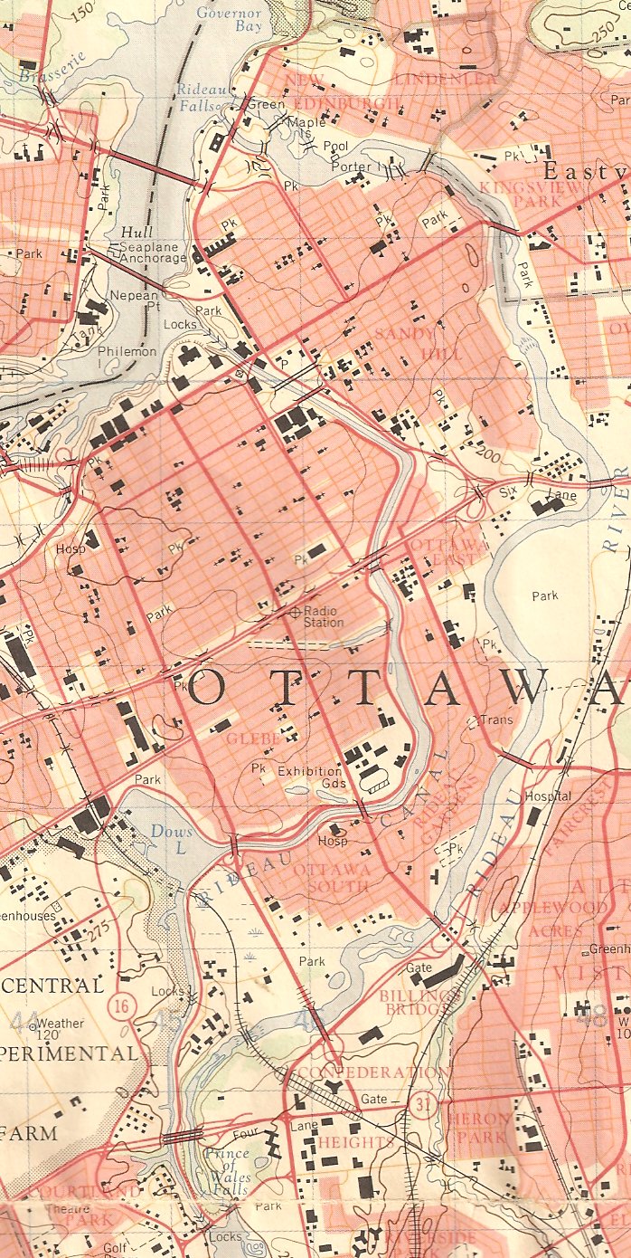
The Rideau River and the Rideau Canal both flow through the City of Ottawa. Their geographic relationship can be seen on the following map.
The Rideau River flows to Rideau Falls on the Ottawa River from Hog's Back on the map. The river is east of the canal and runs,
more or less, parallel to it. Hog's back is shown as Prince of Wales Falls at the bottom of the map. There is a lockstation there.
The Rideau Canal was built to the west of the Rideau River. Completed in 1832, it empties into the Ottawa River beside the
Parliament Buildings in downtown Ottawa.
The headwaters for the River and Canal system are in the Big Rideau Lake, halfway between Ottawa and Kingston. From the Big Rideau,
the canal flows south to Kingston and north to Ottawa.
Map Source, below: Extract from Topographic Map of Ottawa, Ontario, Canada, Scale 1:50,000
produced by the Surveys and Mapping Branch of the Department of Energy, Mines and Resources, 1984
May 5, 2010:
Thanks to Allen Craig who has sent in the following map:
Map Source, below: The source info is as follows Sheet 31 G 5 ; scale 1 mile to 1" or 1:63,360.
Surveyed by Geographical Section G. S., original survey 1923. Revised 1935.
Published by the Geographical Section, General Staff, Department of National Defense. Reprinted 1940

April 22, 2011:
Thank you for this interesting page on Hogs back and Dows Lake.
I am a Dugas from Ottawa, though our paternal family came from Cornwall, Ontario. I just wanted to point out that the
Lebrush family mentioned living at hogs back in 1847 is very likely a Labreche dit Dugas as Steve Wall pointed out.
In the book where the map originated we find the following quote:
Joseph Labreche also called Dugas and called Lebrush on the map was the son of settlers at Nouvelle Longueuil and
had himself been a day labrourer in the Argenteuil seigeury in 1814. He lived in Clarence township in Russell County
from 1823 to 1825 and in 1829 we find him working on the canal near Bytown page 24 -
The city beyond: a history of Nepean, birthplace of Canada's capital, 1792-1990, by Bruce Elliott
This particular Dugas-Labreche family line descends from Jean Ducas (Dugas) dit Labreche who immigrated to Quebec before 1708
from St. Pierre, Oloron in Bearn, near Pau, in Southwest France; quite close to the Spanish border. His sons were
voyageurs who travelled the Ottawa River to Nipigon and Makinac Island trading furs. Dugas descendents are quite numerous in
Montreal, Ottawa and points in between today.
I have forwarded the information on Joseph Labreche to a family genealogist for confirmation but there were many Dugas
Labreche in Argenteuil in the early 1800s.
Thanks again for this interesting page.
Sincerely,
David Dugas
___________________________
April 24, 2011:
We have set up a new web page for the LaBreche / Dugas / Lebrush family.
July 24, 2019:
Text Block Below is from page 164 of National Capital Region Heritage
Keywords Hog's Back, Lieutenant Colonel John By


July 19, 2020:
