The Saga of a Bridge - Plans
The Saga of a Bridge
Construction 2011
Construction 2012
Construction 2013
Construction 2014
Epilogue
History & Plans
In 1972, the federal National Capital Commission built a limited access parkway from the end of
Ottawa's Bronson Avenue to the Ottawa International Airport.
Designed for access to and from the airport, all other use by the people of Ottawa was meticulously
blocked. Soon after, the city began to build its long-planned Eastern and Western Communities
(east and west of Bank Street) between Hunt Club and Walkley. However, the
Western Community ended up west of not just Bank Street, but west of
the parkway as well. There was so little change to old plans that Cahill Drive still exists in both
communities, as does a vestigial road allowance for their connection across Bank Street.
Given the long distance north to Walkley and south to Hunt Club Road, communication across the
parkway between the two communities on foot rapidly developed. The parkway was unfenced, and there was a level crossing
over the railway built by the Plante Dairy in 1926. However, crossing the 80 km/hr parkway was
obviously a safety hazard and there were frequent close calls over the years for residents.
13 April 1994: the Hunt Club Secondary Plan and the Ottawa Official Plan include the
original connection between Cahill west and east, just stretched over the Airport Parkway
and the newly-fenced bus transitway (map below)
October 1998: The city gains control of the parkway south to Hunt Club Road and soon
opens north ramps to and from the Airport Parkway at Hunt Club; increased traffic on the parkway
between Heron and Hunt Club increases the danger to pedestrians crossing it. At the same time,
the pedestrian route under the parkway at Hunt Club Road becomes much more difficult due to the
crammed-in access ramps
6 January 2003: the community association passes a motion requesting a safe
pathway linking the Hunt Club Community with the new South Keys Shopping Mall over the Airport
Parkway
14 May 2003: the amalgamated Ottawa council approves an Official Plan that includes the
Secondary Plan's imaginary connection between Cahill east and west
20 September 2004: sod is turned for the first phase of the Sawmill Creek constructed
wetlands; it includes a bridge over the creek near the most widely used path connecting Cahill west
to the South Keys transit station
11 September 2006: the community association passes another motion requesting a
safe footpath
27 September 2007: the Sawmill Creek Constructed Wetland is officially opened; it
includes paved maintenance roads around the complex, but no route for safe public access to them
22 October 2007: Kenny Dagenais is killed crossing the parkway at Cahill Drive, his
mother establishes a roadside memorial for him and begins a relentless personal campaign for a
safe pedestrian crossing at the site of his death
8 January 2008: the community association prepares maps showing possible
routes for a real pathway
4 June 2008: a Statement of Work to study a pathway is approved by Transit Committee; it includes funding for
an environmental assessment, however the RFP is not issued until February 2009 and the EA
contract awarded to Genivar only in April. It later transpires that the original pre-EA schedule
for the project is not modified as a result of this delay despite warnings from Genivar
9 July 2008: Council approves a city-wide cycling plan that includes the imaginary
connection between Cahill west and east
31 March 2009: the community association presents a report
on the number of people who would have access to the Transitway with a safe pathway
23 June 2009: initial planning for the pathway is presented at a public meeting;
comments are requested and collected but there is no feedback to those who commented. The City
has no policy regarding public participation in city projects; no record is kept as to where the
comments went or whether they were considered during subsequent work
1 December 2009: updated plans for the pathway are presented at a public meeting; again
comments are requested and collected, again there is no feedback to those who commented nor any
evidence that they were considered by project planners
16 December 2009: the environmental assessment recommends the bridge proceed
6 January 2010: Transportation Committee approves the >environmental assessment
13 January 2010: Council approves the environmental assessment
13 April 2010: request for design proposals is issued; 4 are received, Genivar and
Delcan are shortlisted
25 August 2010: the design contract is awarded to Genivar
8 September 2010: the first meeting is held of a "Public Advisory group" to "oversee
pathway progress"; the membership is not released, nor is its mandate or reporting authority; a
second equally secret meeting is held two months later
7 December 2010: the detailed construction plans for the pathway are presented at a
public meeting; yet again comments are requested and collected, yet again there is no feedback to
those who commented nor any evidence that they were ever considered by project personnel
24 May 2011: the construction RFQ is issued; 5 bids are received. Despite concerns
by Genivar designers (personal verbal communication, later confirmed by
legal documents) that they could handle such a complex
project, L.W.Bray is selected
22 June 2011: the ceremonial first sod is turned
6 July 2011: construction work begins
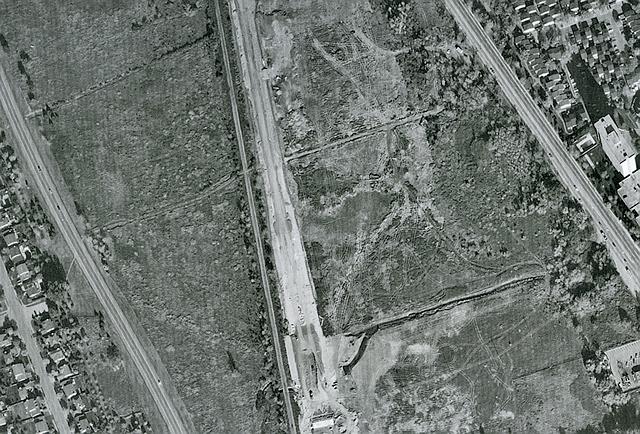
the pathways from the air in 1994, before the building of the South Keys shopping center and
before the opening of the north ramps at Hunt Club; construction of the bus transit station is
just beginning. Many people use the road and level crossing built by the Plante Dairy to reach
Bank Street; a second path leads from Mina Lane to a field boundary but seems to not be used to
cross the railway
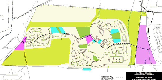
Ottawa Official Plan 1994 showing the imaginary pedestrian route across the Cahill gap
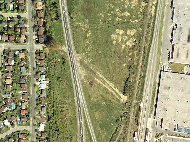
the pathways in 1999, after South Keys Shopping Center and the Hunt Club ramps open, but before
the constructed wetland and O-train; the old path from Cahill is no longer used due to fencing
of the transitway; the new route is via the railway underpass, crossing the transitway via the
South Keys station
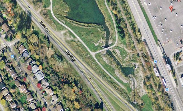
the pathway just before start of construction of the new bridge; everyone uses the bridge over
the creek then continues as before through the railway underpass and the South Keys station. The
roads around the wetland are accessed at several points from the parkway with people parking at
the side of the road; there is no formal pedestrian or cycle access
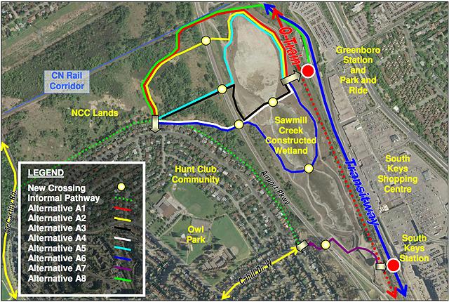
the alternate routes officially considered during the EA, A7 from Cahill to the South Keys
bus station and shopping center that everyone knew in advance was the only real solution, the
others from the north end of Plante Drive to the Greenboro O-train station and nothing else. Yes,
A7 was chosen
the initial plan for the pathway includes pedestrian stairways to shortcut the slopes required
for handicap and cycle access and uses the existing tunnel under the railway. The long limited
access section between railway and transitway embankments to the transit station building concerns
safety advocates, as does winter maintenance of the stairways
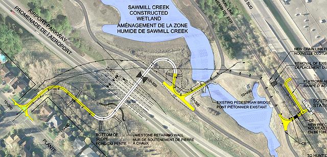
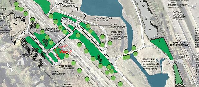
the second plan omits the stairways and, following a decision that the old underpass would not
last for the 50-year plan for the pathway, provides for a new one. As did the first plan, it allows
for twinning of the parkway in the future (the dashed lines). Slopes are just gentle enough to meet
all accessibility standards for wheelchairs, bicycles and pedestrians without pause sections, while
shortening the total length from the first plan. The bridge portion is in white, new paved pathways
in yellow, existing pathways in grey
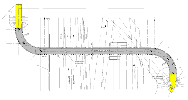
the final plan cleans up the bridge design - it now consists of two identical approach sections,
each a quarter circle of 15 m radius tied to abutment and pillars, and a 75 m
tower-supported straight section
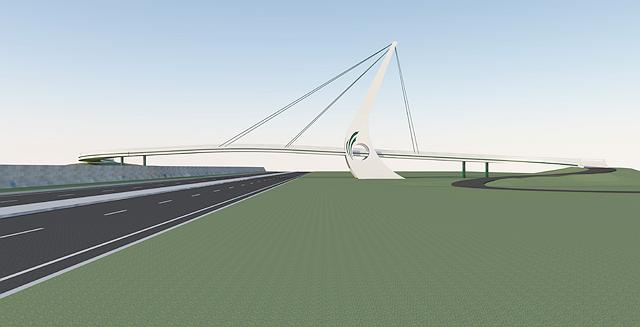
the O-bridge design as it will be seen from the south by those entering Ottawa. The tower height
is 30 m, and is cast in two sections; the deck length is 120 m and is cast in place in
three sections. The O-hole was a late design addition, the drawings presented at the open house
didn't include it. The black line is to be accentuated by night-time LED lighting, as is the O-hole.
The curve of the tower balances the asymmetrical cable load so it needs only
reinforcing steel rod (rebar) construction, without pretensioning elements. A west wall visually
balances the asymmetry of the single tower while protecting the delicate support pillars from
vehicles that could destroy them and bring down the structure. Although described as a cable-stayed
design, it later transpires that the supports are rigid pipes rather than cables; each is to be
welded to the top of the tower and cast into the deck at the bottom rather than to be adjustable as
is usual in such designs; the entire structure will be rigid, not flexible as suspension designs
are. This seems to be the first time this type of structure has ever been proposed for a bridge,
but the public is misled by the description and neither the city nor contractors make any mention
of it
22 June 2011 Official Sod Turning:
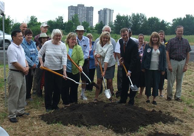
Transportation Committee chair Mariane Wilkinson, River Councillor Maria McRae,
Gloucester-Southgate Councillor Diane Deans and Mayor Jim Watson wield the carefully polished
shovels. At right, Heather Dawson, mother of Kenny Dagenais; at left Jeffrey Waara P.Eng., the
city project manager. Design is by Genivar (now
WSP), building contractor
Louis W. Bray, site engineer Joseph Wheeler. Residents are told
that this is a fixed-price contract for the city, no additional costs ever; they are also told
that they will be able to use the bridge by 31 October
Construction 2011