The Lavant Shagbarks
 Early surveyors noted shagbark hickory (Carya ovata) among the trees along the Rideau River at Ottawa. They were all cut
down for axe handles during the 1800s. However, an isolated healthy population survives north of the Clyde River at
45°08'N 76°35'W in zone 4b.
Early surveyors noted shagbark hickory (Carya ovata) among the trees along the Rideau River at Ottawa. They were all cut
down for axe handles during the 1800s. However, an isolated healthy population survives north of the Clyde River at
45°08'N 76°35'W in zone 4b.
Since the native range of the main population of C.ovata stops just north of the St. Lawrence River, and due to other
differences from main population trees, the consensus of experts is that these trees should be considered as a subspecies
of shagbark: we have informally named it C.ovata lavanti. They are believed to be the most northerly-climate
naturally-reproducing population of their species in the world. They are extraordinary trees, growing right up to the
tops of the most exposed, driest rocky ridges. The Clyde River was a well known canoe route of the Algonkians, and it
is possible that these trees are descendants of some planted by them. Their distribution suggests an origin prior
to the mini-ice age centered on 1500 AD. Young trees are scarce, limited to a few areas where their seed has washed down
from higher trees (in pink on the map below).
Deer and ruffed grouse droppings are common throughout the area. There are many red squirrels but little activity by
woodpeckers, however all woodpecker holes are well defended by red squirrels who use them to store nuts. No sign has
been seen of hare or of any predator of red squirrels; grey squirrels seem limited to the roadway.
C.ovata lavanti betrays its northern adaptation with its seed production. Southern trees tend to set seed almost every
year to support grey and fox squirrels, who bury their nuts so that any missed will grow, often some distance from the
parent tree. Northern trees, however, have to co-exist with red squirrels, who cache their nuts in dry locations such
as hollow trees where they can never grow. The optimum northern strategy is to "flood the market" at widely separated
intervals, the gaps in production preventing the growth of a destructively large population of squirrels.
Very few Lavant trees set significant seed over 2000-2. One tree had a good crop in 2002, and 450 nuts were
collected for propagation; most sprouted successfully. Collections in 2003-4 were similar; the nuts obtained
these years were given to the Ferguson Forest Center for germination and
distribution. In 2005, there was essentially no crop; in 2006-7 red squirrels collected all the seed before
it was sufficiently mature for propagation. In 2008 seed was obtained for propagation. Red squirrels got
all the seed 2009-10. In 2011, no sign of any squirrels was found, perhaps a pine marten or goshawk had paid a visit.
We found 270 good seed, all dropped during a storm a few days earlier, under over a dozen trees, the largest number of
bearing trees we've ever found. All were found east of the logging road; as in past years, none were found under the
higher growing trees west of the road
The preservation of the obviously unique genome of these trees has begun at several sites.
The main one is in the Ottawa Greenbelt, under the aegis of the National Capital Commission, well isolated from any
other hickory populations.
Besides the preservation of the genetic diversity of Canada's forests, this genome is worth preserving for a second
reason: its potential as the foundation of a nut growing industry in Canada. Few nuts other than black walnut have
any such potential in Canada due to our cold climate. The hardiness of this species might open up significant areas of
Eastern Ontario to orchard culture that are not presently usable for this.
The site has been identified as a Renewal and Tending site in the 2006-2026 Mazinaw-Lanark Forest Management Plan of
the Ministry of Natural Resources of Ontario, and a preservation plan for the trees is included in the 2006-2011 FMP.
In 2012, a group of eight shagbarks was discovered on private property near Burnstown, 33 km north of
the Lavant site. They grew from seeds planted by the current owner's grandfather. Jim Ronson has found that the
seed was obtained from a relative of the current owner whose descendants still live on the French Line close to
the Lavant site. There are hundreds of seedlings growing under these trees; many have been moved to Sawmill Creek
and to other Ottawa sites to enable them to grow.
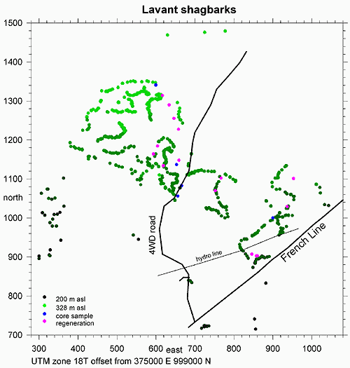
| The trees. Coordinates are UTM zone 18T NAD83 offset from 375000 east 999000 north. The trees are not in
lines. Their positions were measured with a Magellan 315 GPS. This unit has proven itself to be totally unreliable,
routinely indicating positions up to 100 m variance in northing while displaying an EPE of less than 1/10th that,
and having no way to reinitiate averaging. Choose another manufacturer for your GPS - in 2013 I recommend Garmin 62s.
|
| 
|
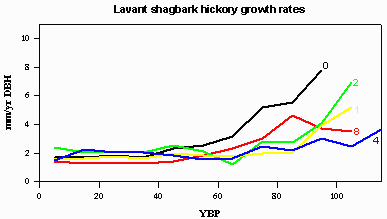
| Growth rate (10 year averages) of five typical trees, at breast height, covering the range of altitude at the site.
Their locations are shown on the survey map in blue; numbering is from low altitude to high. All the trees are very close
to the same age. It seems that there was a clearcut in the 1880's and that the resulting site conditions strongly
favoured shagbark regeneration. There is also evidence that shagbarks were selected over other species. One selection
must have taken place long enough ago that the downed trees have decomposed. A second involved the removal of ironwood
approximately 1985.
|
| 
|
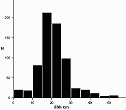
| distribution of DBH (diameter at breast height). 578 trees: 71 double trunk, 11 triple trunk, 2 5-trunked.
|
| 
|
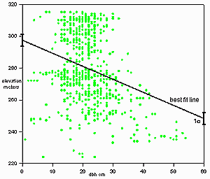
| correlation of DBH with elevation: larger trees tend to be at lower elevations.
|
| 
|
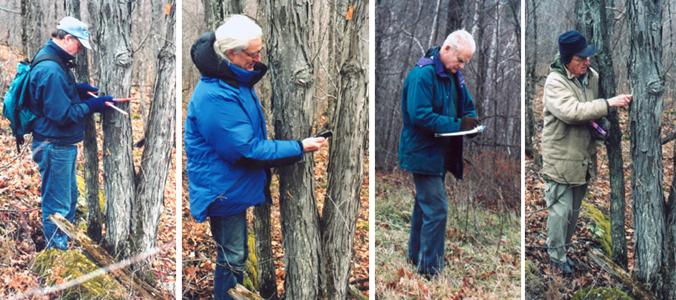
The survey team 2001: Jim Ronson measuring DBH, John Sankey reading GPS coordinates, George Truscott
writing everything down, Len Collett marking the tree as recorded.
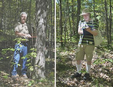
The survey team 2010: John Sankey, Murray Spearman measuring DBH and chalk marking, Arthur Sankey
writing down the data.
John Sankey