Background
Matheson Road, in the neighbourhood of Carson's Grove in the City of Gloucester Ontario Canada is 1.6 km long, entirely residential, with 85 moderate-value detached family houses, a local elementary school and two playgrounds. It was designed to collector specifications (50 km/h) although it is signed at 40 in an unsuccessful attempt to reduce speeds below the design speed. Parking is restricted to one side, but is little used except around the playgrounds. Traffic volume on the road is low for its design, 150 per hour during the day. But, a few drivers travel at speeds that scare residents. And, some drive so aggressively at peak periods that residents fear for their children's safety around the playgrounds, particularly in the new section, which has much greater setback than the old section, and no trees yet.
The first reaction of residents was to get more police with radar guns, and to use the speeding tickets to pay their salary. The province of Ontario, however, required at the time that fines resulting from court convictions be paid directly to the provincial treasury. (This was to forestall the temptation to set up fake speed traps and red lights to fund general town operations, as a remarkable number of American towns did for years without being called to account. Unfortunately, this has changed, and Ottawa is now deliberately using traffic offenses as a revenue source.) So, hiring more police would have raised taxes then, impractical under provincial pressure to reduce them. And, since speeding is a provincial offense, only police are permitted to issue speeding tickets - inexpensive municipal volunteers/employees can't. (A police constable with vehicle cost us $55/hr including support and overhead at the time, 1998.)
In the United States photo radar does the job. But, in Ontario, photo radar was banned by the province, after a politically convoluted campaign succeeded in persuading a basically law-and-order government to put the right of criminals to not have their photo taken on public roads ahead of the safety of the law abiding populace. (Photo systems are allowed for running a red light, because the owner of the vehicle is deemed to be responsible for that - only a photo of the license plate need be obtained, and such systems are being deployed in Ontario. But, speeding is deemed to be the responsibility of the driver, and photo driver identification is deemed to invade privacy. Lawyers!!)
Radar speed advisory systems such as the one shown at right have proven to be effective, both in slowing traffic and in calming residents who perceive vehicles to be travelling faster than they really are. But, in 1998 they cost almost as much as concrete bulges etc. for a whole street, and were too susceptible to vandalism to be a viable permanent option. (This has now changed; they are sufficiently inexpensive to be useful as a local speed control option.)
So, as a last resort, the area was studied to see what if any benefit could be obtained from traffic calming techniques.
It got off to a rocky start. A staffer buried in City Hall, who knew nothing about the patterns of use of the road by the community, proposed painting fake bicycle lanes down each side of the street, parking and non-parking alike. The instant reaction from residents was, "No one uses bicycles here! And, what about our parking?" The answer was a bland assurance that it was perfectly legal in Gloucester to park on bicycle lanes! The local cycling committee joined forces with residents in a charge on City Hall, and the Director of Works was told by the mayor to take charge of the project.
Next, a steering group of residents of the street was formed, including me as chair of the city safety committee, and public consultations began in earnest. And, given the obvious lack of expertise within City staff, an expert consultant was hired.
Learning about Traffic Calming
It quickly became apparent that most residents had several significant misconceptions about traffic calming:
- Everyone wants to believe that their problems are caused by someone else. But, police data on cars stopped for speeding on Matheson showed that almost all of them were local - that is, they were being driven by people who lived or worked within a kilometer of the site. This is an important fact - traffic management (volume reduction of through traffic with options) is best handled very differently than traffic calming (reduction of speeding and dangerous driving by drivers who must use the road).
- People focus on slowing down cars, not on calming drivers. But, arbitrary slowing increases the percentage of annoyed drivers, who feel that they are being hassled, which makes many undesired vehicle problems worse, not better. Traffic calming is most effectively viewed as frustration and anger reduction, for drivers and for residents.
- People place far more faith in stop signs than is warranted by studies of driver behaviour. Smoothly flowing traffic generally creates fewer problems than stop-and-go. Most drivers are well aware of when stop signs are being used solely to impede smooth traffic flow, and react negatively to them. In fact, a number of studies have found that average vehicle speeds actually increase away from an intersection after an all-way stop is installed.
So, the first job of the steering group was to help our community focus on the right question to ask before implementing traffic calming: what is it that makes drivers feel that it is safe to speed on a road? When they do, they are intolerant of driving slowly when the vehicle in front of them is, and that produces the scariest driving of all.
The most direct answer is - a feeling of space. If drivers feel that an area is 'wide open', that they can see that there is nothing to make it dangerous to speed up, then many will speed up. If a road is narrow, cluttered with parked cars, and visibility is obviously restricted, almost all will slow down. It didn't take long, travelling about the city with newly-educated eyes, to conclude that on-street parking is one of the best traffic calmers there is. Unfortunately, the City parking bylaw contains a blanket ban on parking on any street for more than 3 hours, so residents are constrained in adopting that solution.
Vertical structures (speed bumps and humps) are rejected by the City of Gloucester on public roads for safety reasons. They have to be marked with obtrusive signs, since road paint is covered by snow here for a third of the year. A hump high enough to be effective in summer can be a serious safety hazard in our winter ice conditions. A hump high enough to affect the speed of a young male in a muscle car requires buses for the handicapped to slow almost to a total stop to avoid injury to their passengers, many of whom are elderly with weak bones. The same is true for ambulances, where a paramedic in the rear is trying to keep a patient alive until they reach a hospital. And, the effect of such a hump on fire trucks, with their solid tires (they have to be puncture-proof), has to be seen to be believed. They are truly incompatible with people feeling safe in our community.
All-way stops are widely believed to be a panacea that will solve all the problems with urbanisation and the automobile that have been building up over the last century. But, Ontario Environment and Energy data shows that each all-way stop near the Whiterock playground would produce excess annual pollutants of 18 tons of carbon monoxide, as well as greatly increased noise near the stop. Many studies show that, when not warranted by traffic volumes or specific reasons such as inadequate sight distance, at least 10% of drivers will essentially ignore the signs and pass through at full driving speed. This results in more collisions, and a false sense of security for pedestrians crossing the street. The Manual of Uniform Traffic Control Devices for Ontario agrees, warning that all-way stops have proven ineffective at controlling speeds except within 60 m of the signs.
So, that left horizontal structures - curb bulges, medians and the like. The consultant prepared detailed plans based on the public input and on technical concerns such as turning-radius data supplied by the local bus operators and emergency services. Then, all residents on the road, as well as other local residents who had expressed an interest in such matters previously, were invited to public meetings to see the plans, then given a month to formulate and express any concerns. Since it is common for people who object to things like this to write, but for those who support them to do nothing, the steering group members individually encouraged residents who supported the plan to write as well. The lengthy preparation paid off - support from Matheson residents for the plan was almost unanimous, and it was approved by City Council at first presentation.
During the initial phase of the project, most residents were doubtful that traffic calming structures would be effective enough to be worth the cost. However, once the Matheson plan was agreed upon and ready for presentation to City Council, residents of neighbouring streets became alarmed that the structures would work too well - that all the local traffic would be diverted to their street! Their last-minute opposition was sufficiently strong that the process might well have been derailed if the Matheson proposals had not had solid support from the ward councillor and from senior staff.
The Selected Plan
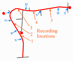
The measures selected (in blue on the map) focus on visibly narrowing the road slightly at busy pedestrian points, and maintaining on-street parking. There are to be road narrowings (N) at busy pedestrian crossings: two at intersections with sidewalks, two at crosswalks, plus a bulge (B) to 'guard' an on-street parking lane the length of the busiest playground (Whiterock). There is essentially no bicycle traffic on the road, so bicycle bypasses through the curb bulges, to prevent cyclists from being forced out into the traffic lane, will not be required. There are to be two short median strips (M): one at the neighbourhood school with its playground, the other at the transition from the new part of the road (wide open, with large house setback) to the old (mature trees and hedges, and smaller setback). The road width is to be divided in three, by a solid yellow center line and a white parking lane, to visually narrow the driving area - most speeders in the old section drive down the middle of the road. The existing all-way stop, located at the south edge of the playground, will be left, although it would not have been recommended by this study. There will only be one new all-way stop, at the exit from a 300 home subdivision under construction (Meadowcroft, upper left on map), where traffic is expected to soon warrant it.
There was initial pressure for an all-way stop at one intersection where most of the local pedestrian-vehicle accidents occur. However, all the accidents recorded are minor bumps; the vehicles involved were driving very slowly. Examination showed that drivers exiting the side road have to drive well past the marked pedestrian crossing in order to see whether or not it is safe to proceed, because visibility is blocked by a high hedge and a large evergreen tree. So, rather than an all-way stop, the plan called for removal of part of the hedge.
It is important when designing roads in this way to keep the perceived safe speed consistent. Many accidents occur when there is a sudden change in a road's safe speed. The Matheson Road measures are spread evenly along the length of the road, one about every 200 meters. It is also important to ensure that traffic is not simply pushed onto another street where it is equally undesirable. This issue arose along one section of the road, where a narrow side street, Whiterock (in black on the map), appears to drivers as a shortcut past a wide curve on Matheson. Calming measures proposed for this section are moderate, to contain the desirability of shortcutting. (At the time of the study, Matheson had 8 times the traffic of Whiterock.) The calming measures were also designed to improve the safety of access of children from Whiterock street to their playground.
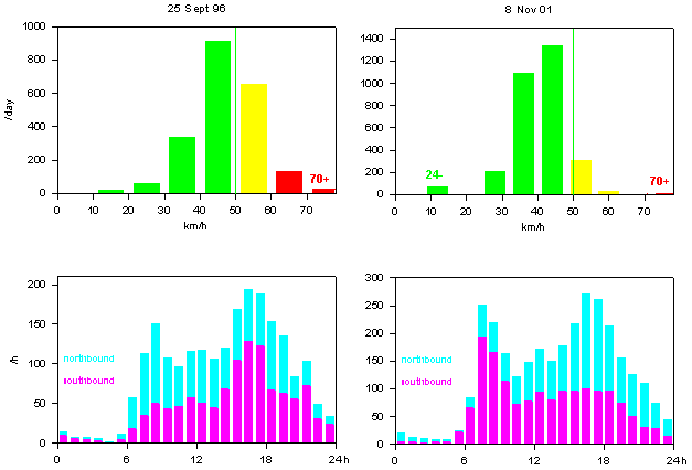
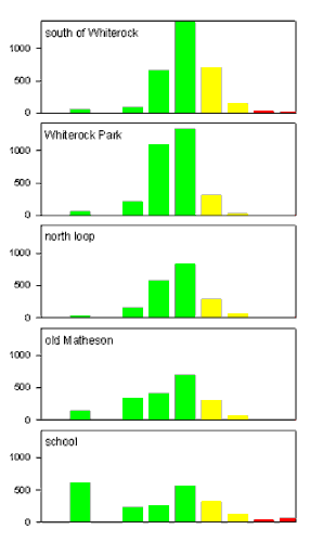
Construction was completed early summer 2000. The total cost was $35 000, plus an estimated increase in snow plowing costs of $1 500 per year. The consultant believed that the average speed of speeders would be reduced between 5 and 10 km/hr. Vehicle data was to be taken throughout the neighbourhood to measure the actual results. In particular, traffic along Whiterock was to be monitored before and after calming measures were in place.
the speed distribution next to the Whiterock playground before calming - the 70+ speeds were almost all southbound in the afternoon
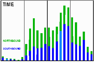
the time distribution - normal except for an excess
travelling south 15:00-18:00
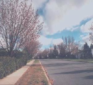
the old section - lots of trees and hedges
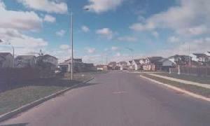
the new section - wide open
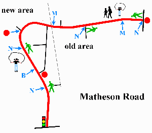
a map of the road
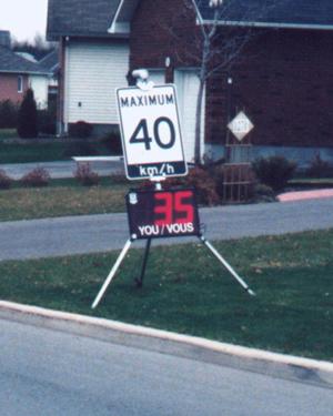
an advisory radar system - effective, but no cost recovery potential.
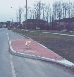
The curb bulge at the Whiterock playground. Traffic calming has costs
besides concrete - every 2-3 months, a vehicle runs over one of the structures,
and the sign has to be repaired or replaced.
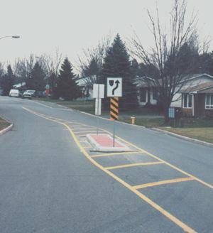
one of the medians