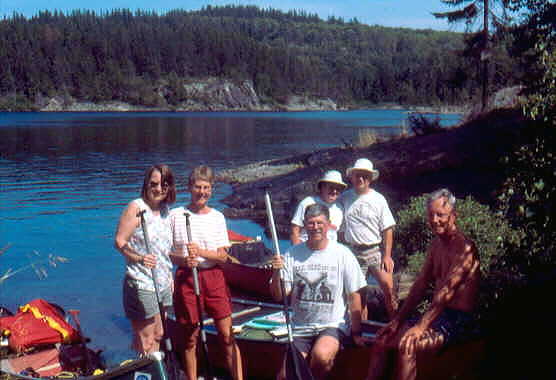
Barbara Bowman, Mary Anne McAlpine, Bill Bowman, Lorna & Richard Guttormson, John McAlpine
Chiniguchi River – Sturgeon River Canoe Trip
July 20-28, 2002
Barbara Bowman, Mary Anne McAlpine,
Bill Bowman, Lorna & Richard Guttormson, John McAlpine
Background
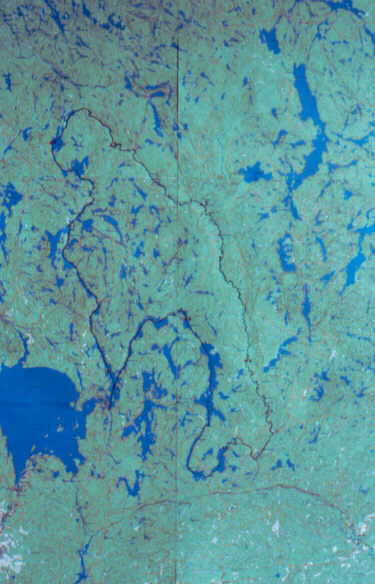
This trip is located north-east of Sudbury, in the southern portion of the Temagami wilderness. Access is at the south end of Matagamasi Lake off the Kugagami Lake Road, which runs north off of Highway 17.
For maps, we used Hap Wilson’s Routes 24, 20 & 1 from "Temagami Canoe Routes" and Toporama maps 41I9, 41I10, 41I15, 41I16, 41P2, which are available on-line from Natural Resources Canada at http://toporama.cits.rncan.gc.ca/.
For resources, we relied on Hap Wilson’s descriptions and a trip log by Glen & Kathleen Larson posted in "Canadian Canoe Routes - A Meeting Place for Canadian Wilderness Paddlers" at http://www.myccr.com/
We are all experienced trippers and river runners, who have paddled together many times.
General Information
 |
This trip has to be rated difficult. It is obviously
little-used, except where it touches cottage country.
Some lakes are very large, which could result in being
wind-bound. The portages and camp sites are not
maintained, and are rough. Some camp sites do not exist
or are so grown in as to be unusable. This is
particularly true on the Sturgeon River below Upper Goose
Falls. The Sturgeon is full of sweepers. We got the
impression that spring floods had tremendously modified
the river banks. On the lower stretches of the Sturgeon,
high muddy banks made take-outs very difficult. Some of
the campsites on Hap’s maps are so poor, that they
should be deleted. Others are not shown in the correct
location. Those mentioned in his text are generally very
good with the exception of Kelly’s Farm, which was
an overgrown mosquito swamp with nearly impossible
access. Speaking of mosquitoes, they were generally not
bad during the day, but were unbelievably thick after
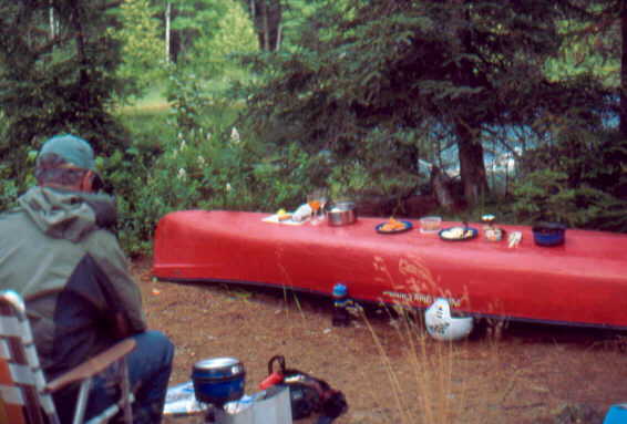
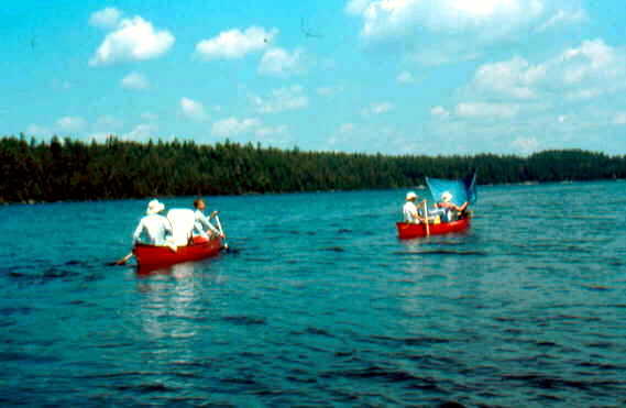
dusk, nearly every night. This is not a trip for white water enthusiasts. Rapids on the Sturgeon are either very easy or not runnable. The rapids that Hap says must be portaged do have to be, mostly because of rocky drops or water falls. Rapid 17 through the gorge was an easy run. The water level on our trip was fairly high, so no lining was necessary on downstream runs. On the plus side, the scenery was gorgeous on the lakes and at the falls. The water in the headwaters of the Chiniguchi was extremely clear and an aquamarine colour. The fishing for walleye and bass was excellent in the upper part of the Sturgeon. Wildlife was abundant, especially loons, frogs, turtles and hawks of several species. We were treated to a close-up of two great horned owls in the daylight. The sense of remoteness was high; we met only a few people, and they were going elsewhere. We had the Sturgeon to ourselves. Lorna counted 26 portages and 7 lift-overs or tracking for a total of 7175m. |
Day 1 – Saturday July 20, 2002
We met at John & Mary Anne’s at 8 am, packed up, and were on the road by 8:15. We drove right through to Corbeil near North Bay, to pick up a Royalite canoe that Rich has rented. Knowing there would be plenty of portages, he opted to pay the bucks and leave the heavy brute at home. We then moved on to the Northgate Mall in North Bay for a late lunch at the food court – a bit of a tradition for us.
After lunch, Lorna moved into the navigator’s chair to guide us to the put-in, which she did admirably. We arrived at Matagamasi Lake at 3:30 pm and found cars parked in every nook and cranny. Many of these were for cottagers near the launch site, as we saw few people on the water. We loaded up the canoes and were on the water by 3:50 pm – not bad.
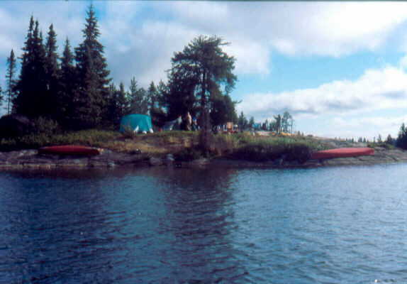
We paddled up the west arm of Matagamasi Lake in good weather and saw a couple camped at a point. At 5:15 pm we found an unmarked island campsite not far beyond the junction of the two arms of the lake. We had a swim and set up on rather lumpy sites. There were many loons who called into the night along with a chorus of bull frogs and green frogs. The mosquitoes were bad after dusk, and we carried hordes into the tents on our clothes, resulting in an uncomfortable night. GPS reading, 0528889, 5181788.
Day 2 – Sunday July 21, 2002
 |
Our first full day on the trip was overcast, but not
raining. Rich erected a tarp to be on the safe side, but
it did not rain much. We packed up and got on the water a
few minutes after 9 am. We continued paddling up the
north-west arm of Matagamasi Lake with a mild tail wind.
Far away, on the eastern shore, we spotted a bull moose
in the shallows. John & Mary Anne paddled over close,
as this was the first one she had seen in the wild. Just
at the north end of the lake, after Rich & Lorna had
already passed, a medium sized soaring hawk passed over
and then soared around and around a small meadow beside
the lake, just a few feet off the ground. John thinks it
was a Swainson’s hawk. From it’s behaviour, it
could also have been a northern harrier. We waded upstream through the rapids, bypassing the first 350-yd portage. It was awkward making our way through the waist-deep water over the rounded boulders. We arrived at a very attractive pond with exceptionally clear water. Ahead lay a falls and portage. I had erroneously marked this 360-yd portage as being only 90 yd. I had misread Hap’s map which stated that the falls had a total 90-ft drop. A scenic swimming lagoon is located between sets of falls on this portage. However, high water meant that getting across to the island that blocked our view would be difficult. That and the grey skies made us skip this potential highlight. We launched on Silvester Lake and went to the west shore to see if we could see the lagoon from there, but all we found were millions of blueberries. Silvester Lake had that same aquamarine clear water, as did the connecting Wolf Lake Wolf was even prettier with all of the rock islands and white rocky shores, reminiscent of Killarney. |
We stopped at one island and enjoyed lunch, wishing that the sun would come out to further enhance the underwater views through the clear water. But it was not to be. We did see three skittish blue herons along this section.
The next 190-yd portage into Dewdney Lake bypasses a double set of waterfalls with a pool in between. We, of course, were fooled into thinking that the first short steep carry over the road to the pool was the whole thing. I guess we were following in the footsteps of many others, because rest of the actual portage was down the road a few steps. As I came to the end of the portage, I met a large group of youth from a Y camp who were just landing. There were perhaps 14 of them, mostly girls about age 15 or 16. Their trip was not long, but included an incredible array of tiny lakes in a loop inside of our path. They were looking tired and dirty as they neared the end of their trip. They had arranged a pickup on Wolf Lake by telephone from Chiniguchi Lake Lodge. We were content to rest and watch them slowly clear the end of the portage. The leaders, only a year or two older than the rest, seemed strong and well organized.
We paddled up Dewdney Lake to the end and found the campsite at the portage to be small, lumpy and buggy – no wonder the Larsens went back down the lake and made their own. The 540-yd portage into Chiniguchi Lake was not bad, though it was buggy. Chiniguchi Lake was a bit confusing because of the islands. There were beautiful cliffs, called the Elephant, which were mostly obscured by the large islands, but did pop into view from time to time. We checked a campsite in a bay, but rejected it. Hap Wilson had one marked ahead around a corner, so we decided to go there. But just out of the bay, at 5:30 pm, we found a well-used site on mostly bare rock., a bit north of Caribou Island. Many people had left their names on the rocks, most dating from the 1920’s to 1940’s. We had to use rocks to hold our tents down on the bare bedrock.
We had good swimming and fishing for small bass. A cormorant flew past, and two fellows paddled by from the north, fishing. They were staying at an old family camp not far away at the north end of the lake, where there is also a lodge. GPS reading, 0524487 5198979.
Chiniguchi Lake
Day 3 – Monday July 22, 2002
Again, we got away just after 9 am. We looked for Hap Wilson’s site, but could find only a very poor one; we were glad to have stopped where we did. We passed the same two guys in their canoe, and then saw Chiniguchi Lodge. The lodge dinner bell began ringing as we passed by – perhaps it was an invitation to stop in for coffee? We’ll never know.
We carried over the 10-yd portage over the road into Sawhorse Lake to find ourselves in a swampy headwaters pond. We had to check the map to find out which bay had the portage. We paddled through lily pads, one with a large bull frog on it, and past colourful yellow flowers. We found the portage, but the trail was along an old grown-in road which headed off in two directions! The map suggested left, but Rich wandered off to the right to have a look, just in case. There was no sign of the spring that Hap mentioned, but the Larsens could not find it either. The trail to the left soon came to a clearing and then followed a good trail to a road. We could go either way, but just to the right was another grassy trail heading in the general direction of Adelaid Lake. We dropped our loads and Barbara took off to check it out. The mosquitoes were fierce, so we were glad of our bug jackets and a touch of spray on the backs of the hands. Barbara returned with positive news, so we shouldered our loads and finished the hike to Adelaid Lake. The portage from Adelaid to Button Lake was marked as 25 yd, but we could find no trace of it. The Larsens’ report was useful here. Hap was coming the other direction, so we might forgive him, but, seriously, the portage is 180 m long and rough. Once again, there were different options. At first we could not find the trail the Larsens used and took the more obvious route over a precarious beaver dam. Coming back, Rich spotted the yellow flagging tape and we went that way with the canoes. I would not advise it because of the waist-height trees down over the trail, and the rickety bridge on the road near the end. Lorna nearly had a fall on the bridge when Rich gave her some bad advice about which board to trust.
We paddled out onto Button Lake and headed for a rock outcrop for lunch, where we hoped to get a breeze to blow away the bugs. What a surprise to hear a motorboat coming our way. It was a couple with a dog who were staying in a camper on Button Lake. They went by us and we soon heard the motor die out. After lunch we headed for the portage to Dougherty Lake and saw their boat at the landing. They were just returning and reported that their 16-year old dog had had a hard time. Indeed, we found this 560-yd portage the toughest of the trip, because of the steepness. I made liberal use of makeshift resting spots for the canoe, to catch my breath.
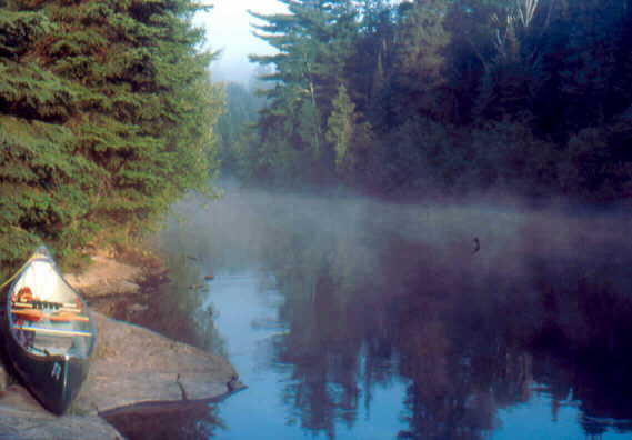
Our reward was beautiful Dougherty Lake. We were now in another watershed, so the water was once again clear and aquamarine. Unfortunately our trip just skirted one side of the lake, so we missed the main event. We portaged 165 yd to Frederick Lake, and paddled past the broken bridge without having to do the 45-yd portage. We found a beautiful unmarked campsite on an island on the west shore and made camp. A sharp-shinned hawk flew over as we were setting up. I lost my Swiss Army knife, but found it again on a last ditch check before leaving the next morning. The swimming and bathing were superb, there were few flies, tons of blueberries, but the fishing was dismal. GPS reading 0522232 5208800.
Frederick Lake
Day 4 – Tuesday July 23 2002
While breakfast was being prepared, I tried fishing with no luck. Mary Anne picked a large quantity of blueberries. Once again, we got under way a few minutes after 9:00 am. Frederick Lake was almost as scenic as Dougherty, with the same clear aquamarine water. We easily found the portage to Stouffer Lake and were eager to use the portage cart with the pneumatic tires. It was not at our end, so Lorna went across the 190-yd trail to bring it back. Alas, she returned empty-handed. The cart that the Larsens had used must have been retrieved by the owners. It was funny, because the portage was rather short and not all that difficult.
Stouffer Lake was pretty too. Then came the dreaded 885-yd portage to the Sturgeon River. But it was not bad at all, a good trail, mostly gently downhill. John got lost at a trail junction that had been quite well marked with sticks indicating the correct turn. When we completed the portage, both John and Barbara did not realize that the stream in front of us was the Sturgeon, but thought it another small lake. We got under way and soon came to two small sets of rapids that were mere rock gardens. Then we stopped for lunch on some rocks in a small lake. I tried fishing with no luck while a pair of small ducks, probably teal, entertained us. I think the female had young as well.
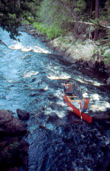
The next two rapids were small rocky falls and could not be run (#11 & #12). The first 160-yd portage was ideal for mountain goats with an incredibly tough descent to the put-in. The second portage was a mere 50 metres away, but we had to paddle it because of a gully at the shore line. This portage was better – only trees to scramble over, and only 85 yds long. John thought it was almost runnable, except for a hole at the bottom. I figured that we could bounce through the hole, but there were too many sharp rocks at the top.
We negotiated a C1 Tech rapids, that was not marked on the map, just before the small lake with the campsites. We also ran #13 with no problem.
Rapid #14 was to be tracked, but we found a route on the left. John & Mary Anne did well, but Rich & Lorna got hung up, and Barbara and I got hung up twice (too heavy in the stern).
The next two rapids were easy rocky types (#15 & #16). We camped at the scenic gorge at #17 – a beautiful campsite. GPS reading 0529610 5209059.
Day 5 – Wednesday July 24 2002
 |
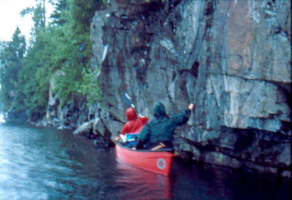
I caught and released a walleye and a bass below the
gorge before breakfast. The rapid through the gorge
looked tougher than it was. The water was deep, and we
all ran it with no difficulty. Rapids #18, #19 & #20 were all shallow easy ones. There was an extra rapid in between for good measure, also easy. Rapids #21 and #22 were both small unrunnable falls. The portage for #21 was difficult, but not as bad as #11. We had lunch before #22, and John scouted it, and declared it runnable except for the very end. So we only had a short carry, but, once again, with a very steep descent to the put-in. We could run #23, but portaged #24 to the small lake with Pilgrim Creek coming in over a falls. The next 9-12 shallow rapids we ran with some scraping. I caught another small walleye and bass which I decided to keep for a snack with supper. We saw a loon fly overhead and a noisy pair of kingfishers. Lorna and Rich saw a beaver with some kits at the lodge. We stopped at the old sawmill. There was nothing but ruins, but the old jackladder was still there. |
We pushed on to Upper Goose Falls, arriving at 6 p.m., very tired. It was a beautiful falls with another gorgeous campsite. There were bare rocks out front for cooking and lounging. We went for a swim and cleanup. When I got out, I noticed that the mini shampoo bottle was no longer in my pocket. Mary Anne spotted it in the river and made a spectacular run to snatch it up at the very brink of the falls. GPS reading 0541223 5201723.
top of Upper Goose Falls
Day 6 – Thursday July 25 2002
We left the beautiful Upper Goose Falls after portaging over the steep trail. The river below was lined with tall sand banks with many trees toppled into the water. We paddled down to the junction of the Obabika River, which came in over a long noisy rapid. It was a great place for a swim. After that the Sturgeon became noticeably more silty.
We pushed on to Lower Goose Falls to find the bridge restored (Hap had reported it washed out). There were a couple of camper trailers high up on the right, but all was quiet. The Larsens had found people on ATVs buzzing around here. The portage was not as Hap described because the bridge reconstruction had eliminated the old one. Instead, we were able to paddle under the bridge and land in an eddy on the left near the top of the falls. This left a short portage across the rocks and sand dunes right beside the river. The rapid below the falls was an easy run.
Then began the twisty section of river that was so obvious on the map. We saw a red-tailed hawk soar overhead several times. We stopped for lunch on a sandbar 30 minutes later. While eating, we saw another hawk, all white underneath with black bars and a grey head – a goshawk, I think.
It was 5 ½ miles to a marked rapids, but we seemed to have paddled for 10 without passing it, when finally, there it was – a CI with sizeable standing waves. It looked like a good fishing spot, but we were beginning to fall behind, so we moved on. Suddenly we saw Rich turn around on his seat and start to paddle furiously back upstream. He had knocked off his glasses into the drink while swatting a deer fly. Of course it was hopeless, but he along with Lorna, Barbara & John dove repeatedly to look for them in the silty water. I knew that I had no chance with my poor underwater swimming ability, so just waited and hoped. John told a very bad joke about a guy looking under a light because he could see better, even though it was the wrong spot.
Resigned to the loss, we moved on towards Kelly’s Farm, thinking to stop sooner if either of the two sites on Hap’s map were any good. Alas, we could find no trace of them. After passing a second CI, we knew we had no option but to press on all the way to Kelly’s.
We saw yet another hawk (Coopers?), then a kingfisher. We heard a rattle of pebbles and looked over to see an incredible sight. A large snapping turtle was attempting to descend the steep bank, but rolled upside down and slid all the way into the river on its shell. Ahead we spotted a mother merganser with four new-born chicks – the smallest I have ever seen.
John & Mary Anne and Rich & Lorna gradually opened up a lead on us and disappeared around one of the countless bends in the river. They landed at Kelly’s Farm and were shocked and disappointed in the poor conditions. The river bank had collapsed leaving a muddy morass at the shore, in which they sunk up to their knees. The site itself was all overgrown with weeds and the mosquitoes were unbelievably thick. After looking around, they decided to return to the canoes and head back upstream to meet us and camp at a sandbar they had passed.
The tenting spots were on pure fine sand, which is tolerable occasionally provided it does not rain. Of course it did that night. The others had brought droves of mosquitoes with them from Kelly’s, so bug jackets were needed full time. As we were having our supper, a lone dragon fly zoomed in amongst us and began picking off the mosquitoes, much to our delight. We made a small beach fire to burn our accumulated garbage and then turned in, serenaded by a bull frog and the droning on gazillions of mosquitoes. GPS reading 0547309 5182221
sandbar campsite
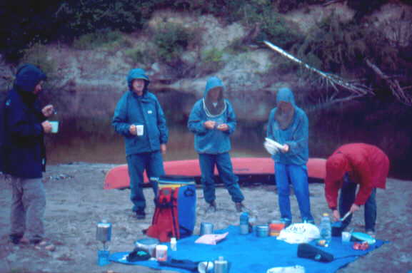
Day 7 – Friday July 26 2002
Rain! What could be worse on all that sand. We ate a quick breakfast in the drizzle and were on the water by 8 a.m. Our tents and packs were covered in wet sand, and it got all over the bottom of the canoes – what a mess!
It took 3.5h to paddle to Floodwood Chutes. During that time we saw 4 kingfishers and 2 great-horned owls. The owls were in trees right at the river’s edge. We could have had some great pictures if it were not for the steady drizzle. We also saw another family of mergansers, this one with older chicks.
Floodwood Chutes were rated CIII, so we were hoping for a chance to run them. But alas, there were 2 big drops which I would rate a solid CIV – not a place for open boats. As with Kelly’s Farm, the landing was in ooze up to our knees. And the takeout was steep and slippery with mud. We were forced to haul everything up bucket-brigade style. The portage itself was not bad except for the steep rocky end. We scrambled out onto the rocks for a view of the chutes and to have our lunch.
We paddled down the now rocky channel of the Sturgeon for another 20 minutes until we came to the junction of the much clearer Chiniguchi. We bade goodbye to the Sturgeon and immediately began lining up the rapids of the smaller river. We had 4 sets of rapids to track up, and on the last one, I stumbled, fell in, and barked my shin.
We paddled on against the current, strong at times, until we came to the 340-yd portage. We had trouble finding the take-out and trail, and could not find the put-in at all. So we continued portaging up the road to a driveway at the 30-30 Club, where we obtained permission to launch there into Lower Murray Lake. At least we had skipped one lift-over by doing the longer portage. The friendly people were from Chelmsford. We finally gave our canoes a complete bath, inside and out, to get rid of the sand.
At the next lift-over, at the far end of the pond, John & Mary Anne paddled up with some difficulty. We decided to try too, but half way up, we hit a rock. The canoe swerved suddenly, and Barbara was ejected neatly right out of the canoe. She was quickly carried back into the pond by the strong current. Bill swung around to fetch her and Rich & Lorna arrived to assist her to shore. She was shivering, so did a complete change of clothes, while I paddled on into Murray Lake.
We stopped at the first decent campsite at 6:30 p.m. The rain had stopped, so we put up lines and hung up our tarps and other things after washing the sand off them in the lake. We hauled up a canoe to use as a table. It was a nice flat site, but there was a swamp in behind. As darkness fell, the mosquitoes became really, really bad. We dove for the tents, and I even forgot to take the GPS reading. There were lots of green frogs and bull frogs calling during the night.
Murray Lake camp
Day 8 – Saturday July 27, 2002
Sunshine! We left our camp site at the north end of Murray Lake at 9 a.m., and headed south. John checked out the camp site at the point and declared it the pits. Barbara decided to hang my wet laundry on the gunwale to dry and promptly lost a T-shirt and a pair of underwear overboard. We quickly covered the distance to the dam and portage. There were a few cottages on Murray Lake, the first we had seen for several days. There was also a lodge at the dam. We saw a merlin near the takeout, but not the osprey that Hap said to look for.
Washagami Lake had many more cottages. The camp site was at the little point, not where shown on the map. We stopped there for lunch and a swim. After lunch we tried some sailing, since the moderate breeze was behind us. The next portage around the dam to Maskinonge Lake was even easier than the last one. The lodge had a fleet of rental canoes, including some voyageur north canoe replicas; so John and I wandered over to chat with the girl in charge. When she heard about our trip, she was envious. She said that the big canoes were mostly used by the youth camp at the north end of the lake.
Maskinonge Lake was a large one, but the gentle breeze was at our backs. We saw in the distance where the 2-mile portage from Kelly’s Farm came out, and then the youth camp with more voyageur canoes. We easily paddled through the two narrows to Rice Lake and Lower Matagamasi Lake without having to do any tracking.
sailing on Washagami Lake
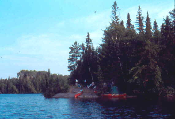
The first camp site was no good, but the second, beyond the point at the north end, was acceptable, if a little cramped. There was some discussion about trying to push on to shorten the very long day on Sunday. But there were 3 more portages before the next camp site, and we figured that was too much. Rich & Lorna had last choice of site, so they had to take one nearly in the water. Barbara and I tried a little trolling, but there was no action. We decided to get up before dawn and get as early a start as possible. GPS reading 0539000 5187976.
Day 9 – Sunday July 28 2002
As prearranged, we rose at 5:15 am in order to cook breakfast and get under way as early as possible because of the long day ahead of us. It was still dark, so I had to use my headlight and bug jacket - a weird sight. As the dawn came on, the mozzies retreated to a more normal level, but a few spits of rain were getting things wet. Lots of things were still damp, but we stuffed them away knowing it would be for the last time before we got home.
We were on the water by 7:00 am, and over the 170-m Edna Lake portage before 7:30. As we approached the portage to Karl Lake, we could see a red canoe wrapped at the end of the rapids. Some fools must have tried to run or line them instead of using the easy 190-m portage. With no time to waste, we left it in its watery grave and hurried on
Lower Matagamsi Lake camp site
At first we had trouble finding the portage out of Karl Lake, because there were two places where the stream came in. But when the map bearers arrived, the mystery was quickly solved. John slipped on the wet round rocks while carrying his canoe, but fortunately was unhurt. Along the portage was a large campsite, where we might have tried to reach the previous night. It certainly was a beautiful area with little falls and rock ledges all over the place. There were delightful pools and riffles to paddle through up to the wooden dam at Matagamasi Lake, which was crumbling with age. The easy 60-m portage was our last of the trip. By now it was 9:30 am.
We paddled down the north-east arm of the big lake for 2 hours to the narrows and stopped for a quick bite of lunch. Rain was threatening. After lunch, we went to examine the rock faces on the west shore, and found several native pictographs, just as the sky opened in a deluge. So much for good photographs!
We paddled on, finally coming to the junction where we had followed the north-west arm at the start of our trip. A couple of cormorants flew past as we turned south and headed towards the takeout. Unfortunately, it was just off the edge of the map, and we could not recognize any landmarks. After searching a bit, we rounded a point and found the takeout eventually.
After seeing almost nobody on the whole trip, it was strange to have all kinds of activity at the takeout. There was even a couple about to start on the same trip we had just completed – except they planned to do the Kelly Farm portage. We advised against it, but it was clear they were going to give it a try. They were nice to us, but seemed to think that they could make better time and do it easier than our elder group. Well, we will never know, but with the size of their packs and wooden wanigan, they would not be doing single carries.
Pictographs at Matagamasi Lake narrows
We got drenched again in another downpour while loading the canoes. I started driving the gavel road with Lorna navigating. When we reached Highway 17, I was so sleepy that I turned the wheel over to Barbara. She drove to Corbeil where we left the rental canoe on the lawn, and then on to Mattawa for dinner at Myrt’s Family Restaurant. Barbara continued to drive to Deep River where we stopped for ice cream at Laurentian View Dairy. I was still too tired, so John took the wheel and drove all the way home while the rest of us dozed. We finally got home at 10:30 pm – a very long day. This marked the end of our most difficult and interesting canoe trip ever.