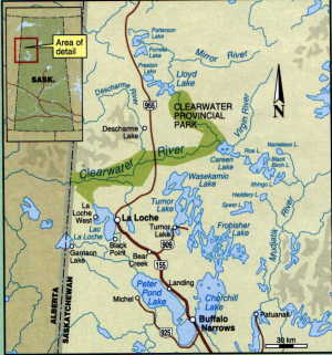
The Clearwater River (based on a trip in July 2000)
Heritage, Canyons & Cataracts
by Bill & Barbara Bowman
![]()
We stood looking down at Granite Gorge, trying to convince
ourselves that the rapids could be run. It was a long Class III
with a canoe-eating rock in the middle of the narrow channel near
the bottom. Skirting the rock would put us over a ledge and into
a huge hole. If we had had others with us for support, it would
have been fun to try and punch through the hole. But we were
alone and far from civilization . This was no time to risk
wrapping our canoe, or worse. So, with reluctance, we headed back
to the top of the portage and began the carry.
We were on the second day of our 8-day mid-July trip on northern
Saskatchewan’s Clearwater River. We do most of our paddling
in the Ottawa area, where we live. But we decided to use the
excuse that our son had moved to Saskatchewan to make a visit and
paddle one of Canada’s premier Heritage Rivers.
The Clearwater is a famous fur-trade river, being the link from
the Churchill River to the fur-rich
Athabaska country. The first non-native to use the 19-km Methye
Portage connecting the two rivers was Peter Pond in 1778. For the
next 40 years, voyageurs and explorers carried their enormous
loads over this, the longest portage on the entire fur-trade
route, creating a well-worn trail still very much in evidence
today.
The Methye Portage meets the Clearwater after it has already come
off the Canadian Shield onto the Interior Plain. Although this
was a bonus for the voyageurs, white water canoeists will prefer
to start their trip further upstream where the Shield rocks
create many kilometres of exciting rapids. Accordingly, we began
our trip with a 45-minute Beaver flight from La Loche to the
confluence of the Virgin and Clearwater Rivers.
The Virgin River is a crystal clear beauty (unlike the
Clearwater, which is slightly silty). We set up camp and cooked a
fresh pike, that we had caught, for supper. It was delicious, but
not quite the grayling we had hoped for. A short paddle took us
to the Clearwater and our first Class II rapids. It was pretty
straight forward, but we were a bit nervous just the same. A good
clean run built our confidence for the many runs ahead of us.
Wildlife was abundant. We rounded a corner to confront a young
moose, which, I am sure, had never seen humans before. It stood
waist deep in the river eyeing us with astonishment. It finally
swam across to the other side and took off up the bank. I thought
it was gone, but Barbara pointed it out up on a ridge peering out
at us from between the jack pines. Descending one of the rapids,
I heard a loud squawk and looked up to see a magnificent bald
eagle warning us away from his fishing grounds. We saw eagles
every day along with sandpipers, kingfishers, hawks, and many
diving ducks. We saw one bear in the distance and had another
check out our campsite one evening. The walleye and pike fishing
was excellent, giving us many delicious meals.
![]()
![]()
![]()
On our first two days on the river, we ran many long Class II
rock gardens and only had a couple of short portages.
Nevertheless, strong headwinds slowed our progress, and we were
obliged to paddle into the early evening to keep to our planned
schedule. Of course, it was daylight until after 10 p.m., so
there was no real need to hurry to set up camp and cook supper.
Campsites were plentiful, and there was no one else on the river
to give us competition for the best spots. The river was full of
sandbars, and the sandy banks were covered with small jack pines
which were coming back after a fire. The forest was very thin,
and we could see a long way back from the river. A short hike up
to the top of these sandy banks led to immense flat areas where
the entire fur brigade could have camped.
On our third day, we tackled Lower Mackie Rapids, which had been
in sight from our campsite. It was more difficult than it
appeared, and impossible to scout from shore. There are two Class
III ledges, the second out of sight around a corner. We ran the
first one down the centre and eddied out for a look The river
turned to the right as it went over the second ledge. We hopped
to the next eddy, craned our necks to get a look at the drop,
then peeled out and ran it along with the Class II portion below
– our toughest rapids so far! We whooped for joy and pulled
in to bail several centimetres of water out of our canoe. We
continued on through the endless rock gardens, almost letting our
guard down. Then, over on river right, we spotted a wrapped
aluminum canoe, a reminder of the power of the river. We wondered
what had happened to the owners, and what we would do if it
happened to us. Would we be able to pull it of with our Z drag?
Fortunately, we never had to find out, but we became keenly aware
that a dump in these rock gardens would almost certainly lead to
a wrapped canoe. After a long tough day, we came to Gould Rapids,
a series of drops in canyon-like conditions, nearly impossible to
scout properly from land. One of these drops was rated Class
III+, so being rather tired, we opted for the 1280-m portage. We
found a beautiful campsite near the end of the portage high up
beside the gorge. Looking down over the rapids, we saw a deer
come down to the water to feed and drink.
![]()
![]()
The next day dawned clear and warm. We broke camp and paddled
down towards Smoothrock Falls, which consisted of three drops
totalling 18 m, followed by a Class IV rapids. We turned on our
GPS to be sure not to miss the portage. Even though the falls
were close, the sound did not indicate the magnitude of the drop.
The 1300-m portage was a tough carry, but the falls were awesome.
We took many photos on the way back for our second load. It was
hot and buggy on the trail, so we had to wear our bug jackets. An
abundance of bear and wolf scat along the trail kept us moving
along at a good pace.
Smoothrock Falls had been a highlight, but it was incredible that
another large falls was just a short distance down river. This
time, even with the GPS, we could not locate the portage. We had
come to a small rapid that led directly into the 15-m series of
drops through Skull Canyon.
![]()
![]()
Could the portage start after this rapid, right at the brink of
the falls? Yes it could! We back-paddled down the rapid, hugging
the shore. It was not difficult, but we were keenly aware of the
consequence of a dump here; and finally, there it was. The
portage around Skull Canyon was short and we could not wait to
drop our packs and race back to see the spectacle. The water had
eroded a near-vertical chasm through
the ancient dolomite rock. It was easy to imagine the outline of
skulls on the canyon walls. We scrambled all around the cliffs to
view and photograph the magnificent falls from all angles.
![]()
![]()
We thought we had finished portaging for the day, but Simonson
Rapids had a different plan in store for us. This is a very long
rapids starting with a solid Class III heading south. The river
then twisted north-west though continuous rock gardens, and then
south again to a Class IV ledge with five different channels
spilling through the islands. We were ready to camp, but, for
once, there was no suitable location. We scouted each of the
channels, but could not find a run we could do. Reluctantly, we
went ashore for one more short carry. Still, there was no
campsite, so we ran the rest of Simonson Rapids and headed down
to Contact Rapids to camp at 8:30 p.m. – our longest,
toughest, and most interesting day.
![]()
![]()
Contact rapids is a very long and difficult set with three Class
IV drops. Since we would have to load and unload three times to
carry around these drops, we took the sane approach and portaged
the entire 1150 m. The trail was very good, we were fresh, and it
was our shortest long portage. We also expected it to be our last
carry of the trip. Indeed, there were no more rapids for 52 km to
our trip’s end at Whitemud Falls in Alberta. We made camp
half way along near the Methye Portage, so that we could hike
part of the historic route. We had trouble finding the start of
the carry, since the meadow at the river’s edge was quite
overgrown. Once onto the route itself, though, we found it easy
going except for the occasional mud hole and hordes of
mosquitoes. It must have been hell for the voyageurs. We hiked as
far as a 700-m hill, and confirmed that the trail was wide enough
for the horse drawn wagons that were used in later days.
On our last day of river travel, we cruised through the many
monotonous loops in the river to finally come to the landmark
flowerpot at the head of Whitemud Falls. We had read that there
was a small creek-like channel that could be run around the
entire falls, avoiding the 405-m portage. We found it in a little
bay just before the brink of the falls (déjà vu). Well, it took
us three hours and dozens of nasty scratches on our canoe and
bodies before we were able to wade through the creek and lift
over 6 large beaver dams. When we finally came out on the river,
we had to paddle upstream against the strong current for 1.5 km
to the campground at the foot of the falls where our plane would
pick us up the next morning. That short portage would have been a
breeze by comparison. The falls consisted of another 15-m series
of drops, not unlike Skull Canyon. There was barely enough
daylight left to hike up and photograph the spectacle.
![]()
![]()
In the morning, our plane arrived, almost on schedule, to whisk
us back to La Loche and the end of our most ambitious and
interesting canoe trip.
To see our complete Clearwater trip log, visit http://www.ncf.ca/~ed143/Clearwater/clearwater log.htm
TRIP PLANNER
Skill Level: Canoeists should be solid Class II paddlers
because of the long rock-filled rapids. July is a good month, as
the upper river could get shallow later in the season
Maps/Info: Horizons Unlimited/Churchill River Canoe
Outfitters c/o Ric Driediger, Box 1110, La Ronge, SK S0J 1L0
Phone/fax: 306-635-4420 Email: ric.crco@sk.sympatico.ca.
For a modest fee, Ric sent us maps and descriptions, and booked
our flights.
Canoe Saskatchewan has lots of details plus UTM coordinates for
rapids and portages. http://www.lights.com/waterways/index.html
Access Points: Lloyd Lake or the Virgin River by float plane:
Warner Bridge by car (not advised to leave vehicles there).
Exit Points: Contact Rapids or Whitemud Falls by float plane.
Fort MacMurray by vehicle.
Guided Trips: Horizons Unlimited/Churchill River Canoe
Outfitters
Flights: Mikisew Air, La Loche, SK (306) 822-2022